Marine World Chart of Nicolo de Canerio Januensis [Book]
This historic book may have numerous typos and missing text. Purchasers can download a free scanned copy of the original book (without typos) from the publisher. Not indexed. Not illustrated. 1908 Excerpt: ...by chance, the expedition of Pinzon. His voyage carried him as far as the coast of Paria, whence he returned, reaching Palos in November, 1500.2 The 9th of March, 1500, Pedro Alvarez Cabral left the port of Lisbon with thirteen vessels bound for Calicut. It may have been by accident that he touched the coast of Brazil, April 22d, at a point near the present Monte Paschoal. He appears to have sailed as far north as the present Porto Seguro, and from this point Cabral departed for the Cape of Good Hope to continue his voyage to Calicut, but Gaspar de Lemos was sent back to Portugal to carry the word of the discovery of a land to which the name Terra de Santa Cruz was given.3 Rodrigo de Bastidas sailed in October, 1500, under letters patent dated June 5, 1500, to discover "islas e tierra-firme a las partes de las Indias, o a otra cualquier parte, con tal que no sea de las islas e tierra-firme que fasta aqui son descubiertas por Cristobal Colon e por Cristobal Guerra." It appears that Andreas de Morales and Juan Rodriguez, pilots, sailed with him, as did also Juan de la Cosa. He first touched the mainland at some point along the Cumana coast, sailed thence westward, at least to the Gulf of Darien and perhaps as far as Puerto del Retrete, including the entire coast of Panama. This part of the New World, however, Canerio omits from his chart. He returned in September, 1502.1 'Navarrete, 1. c., Vol. Ill, p. 547; Venetia, 1556, Vol. I, pp. 132-139; Peter Martyr, 1. c., Decades, I, Lib. ix. Humboldt: Kritische Untersuchungen 2 Las Casas, 1. c., Vol. II, pp. 442, uber die historische Entwickelung der 453; Navarrete, 1. c., Vol. Ill, pp. 23, geographuchen Kenntnisse von der 544, 553. neuen Welt (Ideler's translation from "Ramusio: Navigations et Viaggi, ... « less
Product Specification
-
Authors: Edward Luther StevensonPages: 24Format: paperbackPublication Date: May 18, 2012
-
Universal Product Identifiers
ISBN: 1236149696GTIN: 09781236149695
Related Products
-
T52088 12KW 72 Open Array Super HD W15m Cable
-
Package(c95 with aus, NZ, S. America, Asia Chart, 4KW 24 Inch Digital Radome & Radar Cable)
-
BlueChart g2 Vision - Morgan City to Brownsville - Maps
-
Marine ILIM4060 Auckland LED Reading Chart Marine Light
-
010-00757-00 VHF 300 AIS Marine Radio
-
2841 25ft 26AWG CL2 Standard HDMI Cable - Black
-
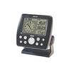
GPS 152 - Marine GPS receiver - 4" monochrome - 100 x 160
-
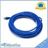
25ft 24AWG Cat6a 500mhz Stp Ethernet Bare Copper Network Cable - Blue
-
Marine -3899-3 St CONNECTOR-THREAD to 3/4 Barb
-
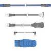
A06028 - SeaTalk NG T-Piece
-
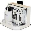
FCF-12000 Feel Cool Fast Marine Air Conditioner by Webasto
-
zumo 550 - Motorcycle GPS receiver - 3.5" color - 320 x 240