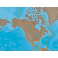
NAM033SD Mega Wide Atlantic CST & Carib
Model: NAM033SD Brand: C-Map
NA-M033 => Atlantic Coast, Gulf of Mexico and CaribbeanCoverage includes most of the eastern coastline of North America. Canadian coverage starts in Arctic Canada and continues east to Hudson Bay, Ungava Bay and Frobisher Bay before continuing south down the Labrador coast to Newfoundland, the Gulf of St. Lawrence and Nova Scotia. Lawrence River is covered down to Montreal. US coverage picks up at Passamaquoddy Bay and heads south down the Atlantic coast, picking up all of Chesapeake Bay, and continuing down to Key West, FL before turning into the Gulf of Mexico. The Gulf of Mexico, from Key West, FL to Brownsville, TX is covered in its entirety. Latin America is covered from the Mexico/US border over around the Yucatan Peninsula along the coasts of Belize, Honduras, Nicaragua, Costa Rica and through the Panama Canal before turning north up the Pacific coastline to Salina Cruz, Mexico. All the islands of the Caribbean are covered, from the Bahamas over to « less
Product Specification
-
Universal Product Identifiers
Part Numbers: 30153, NA-M033SD, NA-M033SDCARDGTIN: 00686074002876
Related Products
-
T-940-4 8.4 Inch LCD Display 4KW 48NM Radar with 4.5' Open Array and 10 Meter Cable 33603
-
MDS-10-4 Radar Sensor 4KW 4 Array 1/8-48 NM
-
JMA-5332-12 Radar 96 NM with 12' Open Array & 19 Inch LCD Monitor
-
EW-C209 Furuno FP Format - Irish Sea
-
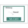
NT+ NA-C603F The Hawaiian Islands
-
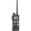
IC-M72 220V Charger Euro with BC-147E 28652
-
34891 Marine 400 Medical Kit
-
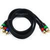
3ft 18AWG CL2 Premium 3-RCA Component Video Coaxial Cable
-
Wiring Device-Kellems HBL63CM64 Connector Body,50 A 3D977
-
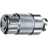
18-8092 3/8 in. Fuel Connector
-
Marine Products Plug, Stainless Steel, 3/4 9-41205
-
VIP-130L-M-IC - IP horn, Marine (White)