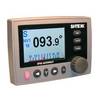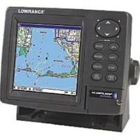
GlobalMap 5200C - Marine GPS receiver - 5" color - 480 x 480
Model: 5200C Brand: Lowrance
A superb new color GPS chartplotter with an external precision GPS+WAAS satellite antenna to allow for custom placement and installation. A 5" screen displays at 480 x 480 resolution with the unique SolarMax enhancement to produce maximum visibility in all lighting scenarios.
Product Specification
-
General
Product Type: GPS receiverRecommended Use: MarineReceiver: 12 channelCard Reader: SD Memory CardInterface: Serial, NMEA 0183, NMEA 2000Compatible Software: Lowrance Fishing Hot Spots Elite, Lowrance FreedomMaps USA Topo, Lowrance LakeMaster Pro Maps, Lowrance MapCreate USA Topo, Navionics chartsSBAS: WAASAntenna: ExternalFeatures: Backlit keypadFirst Seen On Google Shopping: August 2007 -
Display
Type: TFT - colorDiagonal Size: 5"Resolution: 480 x 480Display Illumination: Yes -
Navigation
Waypoints: 1000Tracks: 100Tracklog Points: 10000Routes: 100 -
Connections
Interfaces: Serial -
Miscellaneous
Protection: Waterproof -
Dimensions & Weight
Width: 6.9 inDepth: 3.4 inHeight: 5.4 in -
Manufacturer Warranty
Service & Support: 1 year warranty -
Universal Product Identifiers
Part Numbers: 000-0123-37, 123-37, 5200CGTIN: 00042194529493, 00042194529516, 00042194529561
Related Products
-
E52081E - 4KW Super HD Digital Pedestal w/ VCM100
-
CF651P Central Gulf of MX Plat+ on CF
-
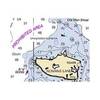
Hecate Strait-Etollin Island Chart
-
BlueChart g2 Vision - Hecate Strait South - Maps
-
010-C1002-20 Bluechart G2 HXEU059RGreenland East Microsd/sd ADA
-
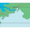
Canadian Charts Strait of Georgia-Central Part
-
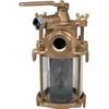
Sea Water Strainers, Flushing, Bronze, 3/4"
-
100ft 24AWG Cat6 550mhz UTP Ethernet Bare Copper Network Cable - Green
-
10ft 24AWG Cat6 550mhz UTP Ethernet Bare Copper Network Cable - Purple
-
Fiber Optic Cable, LC/LC, Multi Mode, Duplex - 3 Meter 2618
-
OK105 18inch SATA Data and Power Combo Cable - UV Blue
-
20110003 SP-36 Second Station Kit W/25' Cable