BlueChart g2 Vision - Hecate Strait South - Maps
Model: Brand: Garmin
BlueChart g2 Vision offers the same rich detailed charting of BlueChart g2 to help you get the most out of your unit. In addition, g2 Vision features a growing database of high-resolution satellite imagery, above and below the water 3D perspective, auto guidance technology, aerial photographs for real world reference and coastal roads with points of interest. This product features coverage of the southern portion of the Queen Charlotte Islands, Hecate Strait, Queen Charlotte Sound, and Queen Charlotte Strait. Includes detailed coverage of many areas including Port Hardy, BC, Burke Channel and Dean Channel. « less
Product Specification
-
General
Product Type: MapsDistribution Media: SD Memory CardFirst Seen On Google Shopping: May 2007 -
Compatibility Information
Designed For: Garmin GPSMAP 4008, 4012, 420, 4208, 420s, 4212, 430, 430s, 430sx, 430x, 440, 440s, 440sx, 440x, 450, 5008, 5012, 520, 5208, 520s, 5212, 525, 525s, 530, 530s, 535, 535s, 540, 540s, 545, 545s, 550, 550s, 555, 555s -
Universal Product Identifiers
Part Numbers: 010-C0695-00, Hecate Strait SouthGTIN: 00753759068752
Related Products
-
Boat (External) Wiring Harness Johnson/Evinrude OMC Black Plug New 473-9430 Instrument Cable Assembly
-
Oregon 450 Handheld GPS c38058
-
CH250BB/88/325 88 kHz Black Box Searchlight Sonar System. Includes 250mm Travel Hoist and Operates at 24 & 32VDC
-
Chart No. 1 Nautical Chart Symbols Abbreviations and Terms: Spiral-Bound [Book]
-
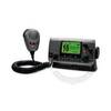
VHF 100 Marine Radio - VHF - 10 Weather - 25W
-
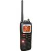
MHS125 Two Way VHF Marine Un MHS125 Mobile Equipmen
-
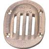
6-1/4 x 4-1/2 Scoop Strainer
-
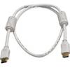
3ft 28AWG High Speed HDMI Cable w/Ferrite cores - White
-
4155 Ferrite cores (1 Pair) for 24AWG HDMI Cable
-
10ft USB 2.0 A Male to B Male 28/24AWG Cable (Gold Plated)
-
Wiring Device-Kellems M4100P12 Plug, Pin/Sleeve, 100 A
-
protective Cover Marine GPS