010-C1002-20 Bluechart G2 HXEU059RGreenland East Microsd/sd ADA
Model: 010-C1002-20 Brand: Garmin
See your surroundings more clearly with BlueChart g2 data. With BlueChart g2, you’ll get detailed marine cartography that provides convenient viewing of nautical content. BlueChart g2 allows you to see your vessel’s precise, on-chart position in relation to naviads, coastal features, anchorages, obstructions, waterways, restricted areas and more. You will also have access to detailed mapping capabilities that include Safety Shading, Fishing Charts, smooth data transition between zoom levels, harmonious transition across chart borders, and reduction of chart discontinuities. Covers: Detailed coverage of the Eastern coast of Greenland from Germania Land around the southern tip of Greenland to Godthab (Nuuk) on the SW coast: Also details Jameson Land, Ammassalik, Julianehab (Qaqortoq), and Nanortalik. « less
Product Specification
-
Universal Product Identifiers
Part Numbers: 010-C1002-20, 10807212, 35804GTIN: 00753759090340
Related Products
-
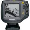
500 Series 535 - Fishfinder - included transducer : XNT-9-20-T - single-beam
-
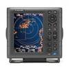
1835 10.4" Color LCD Radar 24" 4KW Dome
-
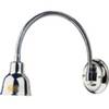
Ocean Chart Lamp, Small
-
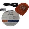
PC Planner NT 128KB for Raymarine
-
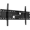
Low Profile Wall Mount Bracket for LCD LED Plasma (Max 165Lbs, 30~63inch) - Black
-
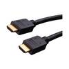
Vanco Installer Series High Speed - Video / audio / network cable - Male 19 pin HDMI Type A to M 19 pin HDMI Type A
-
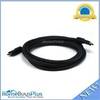
10ft 24AWG CL2 Silver Plated High Speed HDMI Cable - Black
-
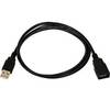
3ft USB 2.0 A Male to A Female Extension 28/24AWG Cable (Gold Plated)
-
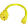
LTD A1530S 15 to 30 Amp 125v/125v Straight Adapter
-
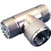
329957-1 UHF T Connector
-
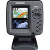
385ci Di Down Imaging GPS Fishfinder with Internal Antenna & Transom Mount Transducer 42460
-
FasFind Max-G PLB w/ GPS