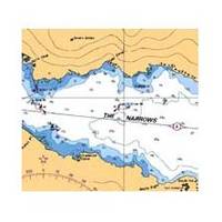
Plans - Saltspring Island Chart
Model: Brand: Plans - Saltspring Island Chart
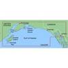
3478; Canadian charts of the Pacific region Encompasses the Strait of Georgia - Canada Note: Ensure that your charts are kept current to reflect changes to that area
Product Specification
-
Universal Product Identifiers
Part Number: 3478
Related Products
-
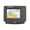
X67-C Sonar [DVD]
-
Package(c125 with USA Coastal Chart, 4KW 24 Inch Digital Radome & Radar Cable)
-
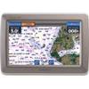
GPSMAP 640 - Marine, automotive Chartplotter - 5.2" color - 800 x 480
-
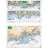
North Shore Long Island Sound, New Rochelle, New York to Norwalk, Connecticut Nautical Marine Charts, Large Print - Waterproof Charts
-
MapSource BlueChart - Anchorage to Juneau - Maps
-
PC Planner for Max Chart without Memory Card c15300
-
10108 Chrome Dual Trumpet Mini Air Hor
-
Nm8213G Male N Connector FRg8u RG213 Cable
-
N2K-T-Rd T Connector Red NMEA Network c30933
-
HP-DFBL260 1 KW HP Bronze Thru Hull Transducer B260 Housing Blue Connector 106-82 wbl260
-
D & W 3840WH 4 Marine Forced Air High Temperature Grille - Always Open
-
GlobalMap 7300C HD - Marine GPS receiver - 7" color - 640 x 480