NaM024 CCard Format u.s.west Coast and Hawaii
Model: NaM024 Brand: C-Map
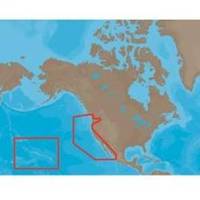
NA-M024 > USA West Coast and HawaiiCoverage of the Pacific Coast of the United States, including all of the coasts of California, Oregon and Washington. Coverage of Baja California and Mexico down to Puerto Vallarta. Detail of the Columbia River, Sacramento River, Willamette River. Snake River and San Joaquin Rivers are also included. Full coverage of Puget Sound and the San Juan Islands up to Point Roberts is also included. Additional coverage of the Hawaiian Islands out to Midway and Johnston Atoll is also included. « less
Product Specification
-
Universal Product Identifiers
Part Numbers: 30132, CMANAM024CCARD, NA-M024, NA-M024-C, NA-M024C-CARDGTIN: 000000165838, 00686074002753
Related Products
-
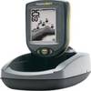
PiranhaMAX 10 Portable - Fishfinder - portable - included transducer
-
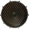
Inked Photography Series Kick Drumhead 22 Inch Boat Props
-
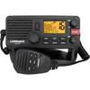
000-10788-001 Link-5 DSC VHF Radio
-
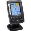
000-10489-001 - Elite-4M Gold Chartplotter, w/Navionics Bundle Lowrance
-
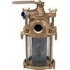
Sea Water Strainers, Flushing, Bronze, 3/4"
-
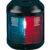
Navigation Light for Bulk Head Mounting , Stern
-
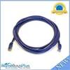
10ft 24AWG Cat6 550mhz UTP Ethernet Bare Copper Network Cable - Purple
-
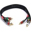
1.5ft 18AWG CL2 Premium 5-rca Component Video/audio Coaxial Cable (RG-6/U) - Black
-
1852061 MKR-US2-1 Garmin Adapter Cable
-
Dgada93m DA93M 3 Adapter Cable with
-
Marine Products Plug Wire Set, Mercruiser V-8, 9-28001
-
1ft 24AWG Cat5e 350MHz UTP Bare Copper Ethernet Network Cable - Yellow