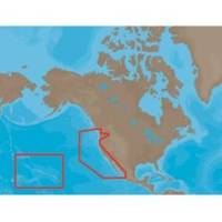
NA-M024 SD Card Format US West Coast and Haw
Model: NA-M024 Brand: C-Map
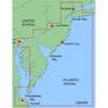
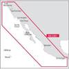
NA-M024 => USA West Coast and HawaiiCoverage of the Pacific Coast of the United States, including all of the coasts of California, Oregon and Washington. Coverage of Baja California and Mexico down to Puerto Vallarta. Detail of the Columbia River, Sacramento River, Willamette River. Snake River and San Joaquin Rivers are also included. Full coverage of Puget Sound and the San Juan Islands up to Point Roberts is also included. Additional coverage of the Hawaiian Islands out to Midway and Johnston Atoll is also included. « less
Product Specification
-
Universal Product Identifiers
Part Numbers: 30147, CMANAM024SD, M-NA-M024, NA-M024-SD, NA-M024SDCARDGTIN: 000000165847, 00686074002746
Related Products
-
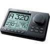
AP35-3 Autopilot with AP35, J300X-40(20A peak), Rudder Feedback RF300 sap35-3
-
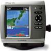
GPSMAP526S Color Combo SOUNDER/GPS w/Transducer
-
G10 10" Mfd W/2KW Sonar 408020-1
-
IN-M002 SD Card Format Indian Ocean
-
MapSource BlueChart - New York - New Jersey - Maps
-
NA-C601 Acapulco, Mexico to Cape Flattery
-
22096366 - Control Head for AP28
-
9388 GPS Interface Cable
-
HF5532 Connector FIT.3/8T x 3/8P-3/BG
-
SmartPlug BF50 50 Amp Boatside Connector
-
3010 Delrin Sleeve for Thru Hull Insulation 32114
-
115V Seawater and Air Distribution Kit for 9,000 BTU Units