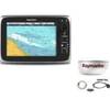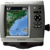
GPSMAP 526s - Marine Chartplotter - 5" color - 480 x 640
Model: 526s Brand: Garmin
The GPSMAP 526 is a compact chartplotter that features a high-resolution, super-bright 5" VGA display along with an improved high-speed digital design for increased map drawing and panning speeds. It's ready to go with a built-in, satellite-enhanced worldwide basemap.
Product Specification
-
General
Product Type: ChartplotterRecommended Use: MarineCard Reader: SD Memory CardInterface: NMEA 0183, NMEA 2000Included Software: Garmin Worldwide Marine BasemapCompatible Software: BlueChart g2 VisionAntenna: Built-inFeatures: Alarm, 2D / 3D map perspective, XM Satellite Radio support, XM weather supportFirst Seen On Google Shopping: December 2009 -
Display
Type: LCD - colorDiagonal Size: 5"Resolution: 480 x 640Features: Anti-glare -
Transducer
Transducer Presence: Included transducerTransducer Type: Dual-beam -
Navigation
Waypoints: 3000Tracks: 50Tracklog Points: 20000Routes: 100Trip Computer: Sun/moon positions -
Connections
Interfaces: Antenna - BNC -
Miscellaneous
Protection: WaterproofWaterproof Standard: IPX7Included Accessories: Protective cover, mounting bracket, power/data cable -
Dimensions & Weight
Width: 5.9 inDepth: 2.9 inHeight: 6.4 inWeight: 1.8 lbs -
Universal Product Identifiers
Part Numbers: 010-00772-01, 010-00772-02, 526sGTIN: 00753759066475, 00753759096113
Related Products
-
Package(c95 with aus, NZ, S. America, Asia Chart, 4KW 18 Inch Digital Radome & Radar Cable)
-
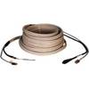
000-167-636 - 15m Radar Sensor Cable for NavNet 3D
-
010-00751-01 - GPSMAP 6212, 12 MFD, Coastal Map
-
NOAA Int Footl/N Pac Ocean/Bering Sea-South
-
The Sea Chart: An Historical Survey Based on the Collections in the National Maritime Museum [Book]
-
9368a Antenna F RapidFix Sat II
-
3" Pipe to Hose Adapter
-
1-1 4 in. IPS Intake Strainer Bronze Made in The USA
-
DA23M - Antenna Adapter Cable for Motorola MOTOROKR
-
BNC-Cp/Gs-01 Connector for Rg-58Au Cable
-
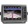
GPSMAP 4012 - Marine GPS receiver - 10.4" color - 800 x 600
-
zumo 550 - Motorcycle GPS receiver - 3.5" color - 320 x 240