ChartKit Book w/ Companion CD - Southern and Centra Map
Model: Brand: Maptech
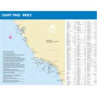
CHARTKIT Book w/ Companion CD Southern and Central California San Francisco to Ensenada, Mexico. Full-color charts, waypoints, courses and distances, marinas, anchorages, chart datums for GPS, and color aerial photos. Save hundreds of dollars on charts. 22 X 17, 71 chart pages. Product Overview New features make ChartKits easy to use with your GPS. Most charts include one-minute lat./long. grids to make vessel positioning a breeze, and major navigation aids are identified with named GPS waypoints. GPS Ready New features make ChartKits easy to use with your GPS. Most charts include one-minute lat./long. grids to make vessel positioning a breeze, and major navigation aids are identified with named GPS waypoints. Small and Large Scale Charts ChartKits include small-scale, wide area charts as well as large-scale, detailed charts of harbors and approaches. The Chart Page Index (inside « less
Product Specification
-
Universal Product Identifiers
Part Number: PAPREGION12
Related Products
-
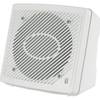
MA1610 Marine Speaker Enclosed Flush, White (Pair) c13381
-
CH250BB/60/225 60 kHz Black Box Searchlight Sonar System. Includes 250mm Travel Hoist and Operates at 12VDC
-
FR8062 12.1 Inch 6KW, 72 nm, 12.1 Color Display Radar 4' Open Array Antenna fr80624
-
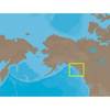
NA-C801 C-Card Format Dixon Entrance - Icy Bay
-
SD/638P+ Pugent Sound Plat+On M155Sd
-
Sd/630P+ E Gulf of MX Plat+On M155Sd
-
788ci HD Di Combo Down Imaging w/TM Transducer
-
30ft 24AWG Cat6 550mhz UTP Ethernet Bare Copper Network Cable - White
-
50 Amp 50' Cord Set - White - 125/250V
-
6ft DB-25(IEEE-1284) Male to Mini/Micro Centronic 36(hpcn36) Male Cable [IE]
-
2206 Terminal Feed Thru 3/8 L Red
-
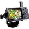
GPSMAP 376C - Marine GPS receiver - 3.8" color - 480 x 320