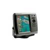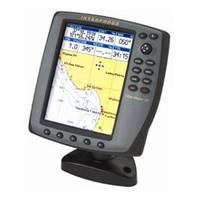
Chart Master153; V6 U1-CHRT-V6
Model: Master153 Brand: Interphase Technologies
V6 and V6I. Combines Amazing Speed, Brilliant Sunlight Readable Color Screen Advanced Features - Joy-stick curser - Fast 200Mhz RISC Processor for super-fast zooms and screen updates.12 Channel WAAS/GPS receiver for outstanding accuracy. - USB interface for future accessories or software upgrades. - Uses C-Map MAX Cartography - V6I includes a WAAS/GPS built-in reciever - Interphase is proud to Introduce its all new Chart Mastera V6 Series - high performance color GPS/chart plotters that offers forward-thinking engineering and features normally associated with high-priced, large commercial grade machines. The Chart Master V6i is completely self-contained with an internal GPS antenna, and the V6 comes with an external active antenna. - One of the first things a boater will notice about the Chart Master V6 series is their vertically oriented high-definition (234x320 pixel) six-inch super-bright color LCD displays. - It's the state-of-the-art engineering inside, however, where the Chart Master V6 series really shines. Both the models combine a new detailed base map of the world, a 200 Mhz super-fast RISC based processor for lightening fast zooms and pans with the outstanding accuracy of 12-channel satellite differential (WAAS) reception. And both sport an easy-to-use, joy-stick pointing device to control the on-screen cursor and select among the many advanced features. - Worldwide Chart Coverage Depth, Distance, Speed Unit Selection Depth Limits Sounding Range Natural Features, Rivers and Lakes, Cultural Features, Land Marks, Tides and Currents, Bathymetric Lines, Spot Sound ings, Bottom Type, Ports and Services, Attention Areas, Tracks and Routes, Lights, Buoys and Beacons, Signals, Cartographic Objects, Names, Compass, Lat/ Long grid, Chart Boundaries, Way Point Icons User Selectable Datum Built-in Worldwide Background Chart - Automatic Information on Cartographic Objects Port Information Goto Nearest Tide Information Simulation/Demo Mode M.O.B.Function North-up or Course-up Forward Looking Depth Alarm Compatible with C-Forecast - TM Report Functions Route Data Report User Points List GPS Data Page Navigation Data Page - Specifications500 Waypoints or Marks 25 Routes with 50 Waypoints/Route 5000 Track Points, 7 Color Tracks 16 Types of User Marks 234 X 320Pixel Resolution 5.7quot; Diagonal TFT Sunlight-Color LCD 256 Colors 0 - 35 VDC , 7.5W Power Non Volatile Battery Back-up Adjustable CCFL Backlight Backlit Keypad Uses New C-Map MAX Cartography NMEA 0180/1083 Autopilot Interface NMEA 0183 Interface CE: EN60945 Compact Dimensions: 3.38quot; W X 4.5quot; H, Approx. 2 lbs. « less
Product Specification
-
Universal Product Identifiers
Part Number: U1-CHRT-V6
Related Products
-
408470-1 581i Di Combo Fishfinder
-
Package(E140W, GPS Antenna, RA1072HD 4KW 72 Inch HD Digital Open Array Radar & 15m Radar Cable )
-
37555 Outdoor US Great Lakes Chart f/Endura Series
-
Cdr10 Digital Chart Kit Pr and US VI
-
GPSMAP 525s - Marine Chartplotter - 5" color - 480 x 640
-
15ft 24AWG CL2 High Speed HDMI Cable w/ Net Jacket - White
-
6ft USB 2.0 A Male to Micro 5pin Male 28/24AWG Cable w/ Ferrite Core (Gold Plated)
-
10gb Fiber Optic Cable, LC/ST, Multi Mode, Duplex - 3 Meter
-
TNC-Cp/Gs-01 Connector for Rg-58Ua Cable
-
Invisible Splice Connector for 3/8 Inch Rope Light - Imt-ilmdl-inv
-
1927.3 Master Controller URC-102
-
RINO 130 - Hiking GPS receiver / two-way radio - Monochrome - 160 x 160