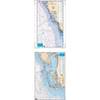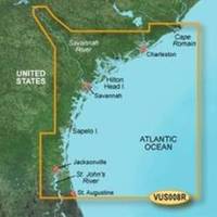
BlueChart g2 Vision - Charleston to Jacksonville - Maps
Model: Brand: Garmin
BlueChart g2 Vision offers the same rich detailed charting of BlueChart g2 to help you get the most out of your unit. In addition, g2 Vision features a growing database of high-resolution satellite imagery, above and below the water 3D perspective, auto guidance technology, aerial photographs for real world reference and coastal roads with points of interest. This product features Cape Romain through St. Augustine including Charleston, Savannah and Jacksonville with the St. John's River covered to the Clay County line. « less
Product Specification
-
General
Product Type: MapsDistribution Media: SD Memory CardFirst Seen On Google Shopping: May 2007 -
Compatibility Information
Designed For: Garmin GPSMAP 4008, 4012, 420, 4208, 420s, 4212, 430, 430s, 430sx, 430x, 440, 440s, 440sx, 440x, 450, 5008, 5012, 520, 5208, 520s, 5212, 525, 525s, 530, 530s, 535, 535s, 540, 540s, 545, 545s, 550, 550s, 555, 555s -
Universal Product Identifiers
Part Numbers: 010-C0709-00, Charleston to JacksonvilleGTIN: 00753759068899
Related Products
-
MT-403FG AccuSat 406 Cat 1 EPIRB Intern GPS Non-Hazmat Withbracket
-
010-C0877-20 Bluechart G2 HXAE002RYellow Sea Microsd/sd Adaptor
-
Understanding a Nautical Chart: A Practical Guide to Safe Navigation [Book]
-
Waterproof Charts 15F Southwest Florida FISH/DIVE
-
CF/38XG XL9 38XG - Moscow Area CF Card
-
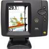
500 Series 596c - Fishfinder - included transducer : XNT-9-20-T - dual-beam
-
6ft 24AWG CL2 Flat High Speed HDMI Cable - Black
-
Video / audio cable - Male RCA to M RCA
-
93-RMDISP01-A Remote Display for InCharger Battery Char
-
Trident Marine Hose 5" x 6" Fiberglass Splicer
-
3ft 24AWG Cat6 550mhz UTP Ethernet Bare Copper Network Cable - White
-
FCF16000 Kit with AC, Seawater & Ducting - 115V FCFK022A