SD651P Cent Gulf of MX Plat+On M155Sd
Model: SD651P Brand: Navionics
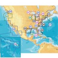
Navionics 651P+ Central Gulf of Mexico Platinum+ Multi-Dimensional Charts, with the most advanced technology and best imaging available, provide high-resolution photo/chart overlay, full-view XGA panoramic pictures, improved 3D view, complete geo-referenced coast pilots. Compatibility Guide « less
Product Specification
-
Universal Product Identifiers
Part Numbers: 11093986, 37666, 651P+, DEF-257882MSD651, MSD, MSD-651P-, MSD651P+, NVNMSD651PP, SD651PGTIN: '82124565159, 00821245651594
Related Products
-
BlueChart g2 Vision - Lake Erie - Lake St. Clair - Maps
-
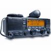
America Inc. M710-21 SSB
-
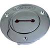
0528007PLB 1.25 Unmarked Deck Fill Bronze
-
Miscellaneous Problems in Maritime Navigation, Transport and Shipping: Marine Navigation and Safety of Sea Transportation [Book]
-
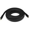
4163 30ft 24AWG CL2 Flat Standard HDMI Cable - Black
-
Cat6a Ethernet Cable | 5ft | White | Network | 10 Gigabit
-
Patch cable - CAT 6 - RJ-45 - M - Unshielded twisted pair (UTP) 10 ft - Gray
-
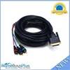
25ft DVI-I to 3 RCA Component Video Cable (DVI-I - 3-rca)
-
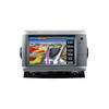
GPSMAP 740s - Marine Chartplotter - 7" color - 800 x 480 - widescreen
-
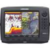
10543001 HDS-10 Gen2 Inst USA w/o XD
-
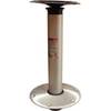
Hi-Lo 9" Fixed Height 2-3/8 Plug-in Pedestal Set - Springfield Marine
-
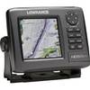
14023 HDS-5m Chart/Gps-No Fishfinder