010-C0764-10 Bluechart G2 HEU005RIreland West Coast Data Card
Model: 010-C0764-10 Brand: Garmin
Detailed coverage of the west coast of Ireland from Cork Harbour to Belfast. Also covers the Scottish coast from the Isle of Colonsay to Campbeltown Harbour. See your surroundings more clearly with BlueChart g2 data. With BlueChart g2, you'll get detailed marine cartography that provides convenient viewing of nautical content. BlueChart g2 allows you to see your vessel's precise, on-chart position in relation to naviads, coastal features, anchorages, obstructions, waterways, restricted areas and more. You will also have access to detailed mapping capabilities that include Safety Shading , Fishing Charts , smooth data transition between zoom levels, harmonious transition across chart borders, and reduction of chart discontinuities. « less
Product Specification
-
Universal Product Identifiers
Part Numbers: 010-C0764-10, 10804854, 35601GTIN: 00753759091514
Related Products
-
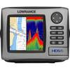
HDS-5 Lake Insight 83/200kHz T/M Ducer 34241
-
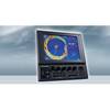
CH270/312 180 kHz Searchlight Sonar System with 10.4 Inch Color LCD Display. Includes 350mm Travel Hoist and Operates at 12VDC
-
Max EN-M082 W28 River Danube-MAX
-
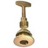
0363DP0PLB Plug Garboard Drain 3/4in
-
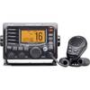
M504 Black VHF Radio with Hailer M504A 61
-
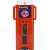
3995.4 Firefly 3 Strobe Same as 3995.3 But Bulk PK
-
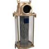
3" Water Strainer
-
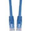
Cat6a Ethernet Cable | 5ft | Blue | Network | 10 Gigabit
-
AFI Chart Light & Cigarette Lighter, Economy, 12Pack
-
DM-LTB-100 Light Bar for Dual Mounts
-
5 Inch Power Mount Aft Lean for Garmin Domes with Light Bracket Option PMA-5N-7L wpma5n7l
-
407150-1M 1157CX 10.4" GPS Chartplotter Combo Internat