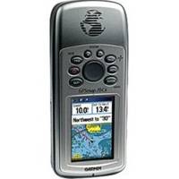
GPSMAP 76Cx - Marine, hiking GPS receiver - 2.6" color - 160 x 240
Model: 76Cx Brand: Garmin
The GPSMAP 76Cx is a refreshing upgrade of the GPSMAP 76C, one of the most popular Garmin's models for outdoor and marine use. This unit features a removable microSD card for detailed mapping memory and a waterproof, rugged housing. The microSD card slot is located inside the waterproof battery compartment. Users can load map data and transfer routes and waypoints through the unit's fast USB connection. In addition, this unit features a new, highly sensitive GPS receiver that acquires satellites faster and lets users track their location in challenging conditions, such as heavy foliage or deep canyons. Considered the mainstay among serious outdoor enthusiasts, the GPSMAP 76Cx offers a large color TFT display and turn-by-turn routing capability. This unit also floats when dropped in the water. « less
Product Specification
-
General
Product Type: GPS receiverRecommended Use: Marine, hikingPreloaded Maps: South America, Canada, USA, Alaska, Central America, MexicoReceiver: 12 channelCard Reader: microSDInterface: Serial, USB, NMEA 0183, RTCM SC-104 DGPSFunctions & Services: MOB (Man Overboard)Included Software: MapSource Trip & Waypoint ManagerCompatible Software: MapSource BlueChart, MapSource US TOPO 24K, MapSource Fishing Hot Spots, MapSource Recreational Lakes, MapSource US TOPO, MapSource City NavigatorGrids: UTM, MGRS, Lat/Lon, User, Loran TDs, MaidenheadSBAS: WAASDGPS: DGPS readyAntenna: Built-inAccuracy: Position - 49 ft Position - 10 ft - 16 ft ( with DGPS ) Position - 10 ft ( with WAAS ) Velocity - 0.16 ft/secUpdate Rate: 1/secondInternal Memory: 115 MB flashFeatures: Custom POIs, preinstalled POIsFirst Seen On Google Shopping: December 2005 -
Display
Type: LCD - colorDiagonal Size: 2.6"Resolution: 160 x 240Display Illumination: Yes -
Acquisition Times
Warm: 15 secCold: 45 sec -
Navigation
Waypoints: 1000Tracks: 20Tracklog Points: 10000Routes: 50Waypoints per route: 250Trip Computer: TracBack, average speed, maximum speed, trip timer, trip distance, sunrise/sunset times, sun/moon positions -
Connections
Interfaces: Serial - RS-232 Serial - USB Antenna - MCX -
Battery
Type: AA typeRequired Qty: 2Run Time (Up To): 18 hours -
Miscellaneous
Protection: WaterproofWaterproof Standard: IPX7Included Accessories: Lanyard, 128 MB microSD Card, USB cable -
Dimensions & Weight
Width: 2.7 inDepth: 1.4 inHeight: 6.2 inWeight: 7.6 oz -
Environmental Parameters
Min Operating Temperature: 5 °FMax Operating Temperature: 158 °F -
Universal Product Identifiers
Part Numbers: 010-00468-00, 76CxGTIN: 00753759051631
Related Products
-
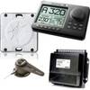
AP2802 Autopilot System AP28 AC42 RC42 RF300 No Drive
-
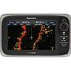
T70007 e7D 7" Multifunction w/Sonar, Internal GPS - Row
-
25ft 24AWG Cat6 550mhz UTP Ethernet Bare Copper Network Cable - Gray
-
20ft 24AWG Cat6 550mhz UTP Ethernet Bare Copper Network Cable - Red
-
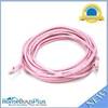
20ft 24AWG Cat5e 350MHz UTP Bare Copper Ethernet Network Cable - Pink
-
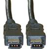
FireWire 6 Pin / 6 Pin 10ft Cable | IEEE-1394
-
Cat6a Ethernet Cable | 10ft | White | Network | 10 Gigabit
-
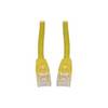
Patch cable - CAT 6 - RJ-45 - M - Unshielded twisted pair (UTP) 7 ft - Yellow
-
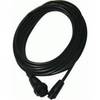
Opc1540 Command Mic III Cable 10617439
-
Air Breeze 30 Land Wind Turbine with Built-In Regulator ar30-10
-
0100075700 VHF 300 AIS
-
GPS receiver remote control - Radio