Waterproof Chart Kit - Puget Sound #WPB1520-02
Model: WPB1520-02 Brand: Maptech
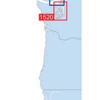
Waterproof Charts w/ Companion CD WPB1520 1520: Puget Sound Covers the entire sound from Olympia to Admiralty Inlet, including Lake Washington. 25 pages of charts, 150 GPS waypoints, Lat. /Long. grids, courses, ramps, and 180 marine facilities. Overview and detailed charts. 12 x 17, scales 1:225,000 to 1:13,000. Product Overview These easy-to-use, compact chart books are ideal for Day-Sailors, Fishing Boats, and Trailer Boats. They measure 12 x 17 (24 x 17 when open) and are made of waterproof, tear-resistant synthetic paper that will withstand the elements. GPS Ready New features make Waterproof Chartbooks easy to use with your GPS. Most charts include one-minute lat./long. grids to make vessel positioning a breeze, and major navigation aids are identified with named GPS waypoints. Small and Large-Scale Charts Waterproof Chartbooks include small-scale, wide area charts as well as large-scale, d « less
Product Specification
-
Universal Product Identifiers
Part Number: WPB1520-02
Related Products
-
SP110VF-8 SP-110 System w/Virtual Feedback & Mechanical Remote
-
T-940-4 8.4 Inch LCD Display 4KW 48NM Radar with 4.5' Open Array and 10 Meter Cable 33603
-
Mini RE-1 Radar engine 2KW 24km 11" 41405
-
Radar Pole Mount 6' Kit for Raymarine 2KW and 4KW
-
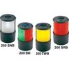
Base Mount White Masthead Navigation Lights Light, 225
-
Kwik Tek Life Jacket Bag, 4 Adult
-
E15026 Life Tag Wireless Man Overboard System (Extra Tags)
-
Navigation Light BAY15d Replacement Bulb 9353384
-
3ft 24AWG Cat5e 350MHz UTP Bare Copper Ethernet Network Cable - Yellow
-
EC7IF Chartplotter w/Internal Antenna & Fishfinder Tan / Red
-
2710 Cover Connector Dual Bus 2702
-
10ft 24AWG Cat6 550mhz UTP Ethernet Bare Copper Network 3435