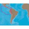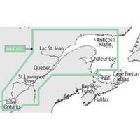
NT+ - St. Lawrence River and Approaches NA-C202
Model: NA-C202 Brand: C-Map
C-MAP has set the standard for electronic charts with five consecutive NMEA awards for "Best Electronic Cartography". The spring 2004 C-MAP NT+ release will include marina detail for over 1,000 US marinas in C-MAPs private collection. Now you will be able to see slip detail as well as the locations for onshore facilities. Finding the right chart plotter for you is easy with 17 manufacturers powered by C-MAP. Just look for the NT+ logo. « less
Product Specification
-
Universal Product Identifiers
Part Number: NA-C202GTIN: 00686074003781
Related Products
-
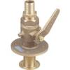
St6001 S1G Hydraulic Outboard sys E12122
-
GPS receiver marine mount bracket
-
Package(c97 with USA Coastal Chart, 4KW 18 Inch Digital Radome & Radar Cable)
-
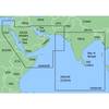
MapSource BlueChart - The Gulf and Red Sea - Maps
-
SA-C001 Furuno FP Format - Peru, P. Vallarta, P. Bolivar
-
0835008PLB Seacock w/Straight TP 1-1/2In*
-
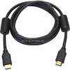
6ft 28AWG High Speed HDMI Cable w/Ferrite cores - Black
-
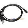
3ft USB 2.0 A Male to Micro 5pin Male 28/24AWG Cable w/ Ferrite Core (Gold Plated)
-
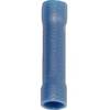
EC04110 Blue 16-14 Butt Connector PK10
-
SS264W - 50kHz - 20 Deg - 10 Pin Furuno Connector
-
A62246 - Seatalk Hs Dual End Network Cable 15m
-
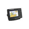
GlobalMap 6600C HD - Marine GPS receiver - 7" color - 640 x 480