NA-M026 C-Card Format Great Lakes and The Maritimes
Model: NA-M026 Brand: C-Map
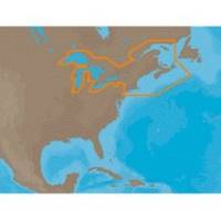
NA-M026 => Great Lakes, Northeast Coast and ApproachesCoverage of the Great Lakes, St. Lawrence River and Northeast United States. Coverage of the Great Lakes also includes Fox River and Lake Winnebago, Lake St. Clair, Rideau Canal, Ottawa River and the Trent-Severn Waterway. Includes all coastal charts for New Brunswick and Nova Scotia in Canada and Maine, New Hampshire, Massachusetts, Connecticut and New York in the U.S. Also included is coverage of the Hudson River and Lake Champlain as well as the Erie Barge Canal. Specifications:Port Plans: YesAerial Photos: Yes3-D View: Yes « less
Product Specification
-
Universal Product Identifiers
Part Numbers: 30127, NA-M026, NA-M026C-CARDGTIN: 000000165840, 00686074002791
Related Products
-
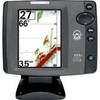
700 Series 777c2 CHO - Fishfinder - optional transducer - dual-beam
-
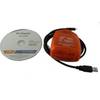
PC Planner F Max Charts W O Memory Card
-
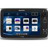
T70052 E125 Multifunction Display w/European Charts
-
Understanding a Nautical Chart: A Practical Guide to Safe Navigation [Book]
-
2744.91 FBRS 2744 Battery Replacement Service
-
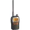
t50421 Marine VHF Hand-Held Radio
-
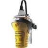
EPIRB Auto Release Cat I, No GPS EP50 Auto c30589
-
D10DX06T D10DX.06T Depth Sounder
-
LED Bicolor Light Black 12V/24V ASL-341007
-
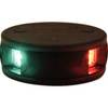
70M Double 360 Degree White Navigation Light
-
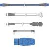
3M Stripped End Spur Cable for SeaTalk NG
-
GPS 152H - Marine GPS receiver - 4" monochrome - 100 x 160