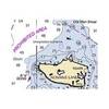
MapSource BlueChart - Southeast Caribbean - Maps
Model: Brand: Garmin
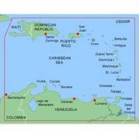
MapSource BlueChart is Garmin's exclusive marine cartography and was developed to provide you with mapping flexibility and options you've never had before. This line of cartography products is designed to provide interactive viewing of detailed nautical chart data, thereby providing navigators with innovative object-oriented cartography. These detailed electronic nautical charts look just like paper charts when displayed on your Garmin chartplotter. Features include shading between depth contours, spot soundings, navaids, port plans, wrecks, obstructions, inter-tidal zones, and more. BlueChart offers much larger coverage areas for half the price. MapSource BlueChart Southeast Caribbean covers the Caribbean from Haiti to Trinidad & Tobago, including Puerto Rico and all of the Lesser Antilles. It also includes the Colombian and Venezuelan coasts from Barranquilla, Colombia to the mouth of the Orinoco River, including Lake Maracaibo and the Gulf of Paria. « less
Product Specification
-
General
Product Type: MapsDistribution Media: Garmin Data CardFirst Seen On Google Shopping: January 2006 -
Universal Product Identifiers
Part Numbers: 010-C0044-00, Southeast CaribbeanGTIN: 00100768725709, 00753759040109 -
Compatibility Information
Designed For: Garmin GPSMap 172C, 176, 176C, 178C, 178C Sounder, 182, 182C, 188 Sounder, 188C Sounder, 196, 2006, 2006C, 2010, 2010C, 2106C, 2110C, 2206C, 2210C, 232, 238 Sounder, 276C, 292C, 296, 298C, 3006C, 3010c, 3205C, 3206C, 3210C, 376C, 392C, 396C, 492C, 498C
Related Products
-
120-2580-01 Shadow Drive for Verado Autopilot
-
U1-CHRT-PRO Chartmaster Pro Combo - External
-
E127 Multifunction 12" Display with Sonar - US Inland Charts T70057 c44354
-
JMA-5110 Black Box Radar 72NM, 10KW with 6 Foot Open Array (without LCD Display)
-
Puget Sound (Small Craft) Chart
-
GSC Autopilot No Rudder Feed Back or Drive 700048-1
-
E70033 TH32 320 x 240 Thermal Marine Scope
-
250ft 18AWG CL2 Rated 2-Conductor Loud Speaker Cable (for In-Wall Installation)
-
3ft eSATA + USB to Esatap Cable - Black
-
GPSMAP 4012 - Marine GPS receiver - 10.4" color - 800 x 600
-
GlobalMap 7600C HD - Marine GPS receiver - 10.4" color - 600 x 800
-
n�vi 2350 - Automotive GPS receiver - 4.3" color - 480 x 272 - widescreen