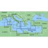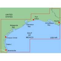
MapSource BlueChart - Morgan City-Brownsville - Maps
Model: Brand: Garmin
MapSource BlueChart is Garmin's exclusive marine cartography and was developed to provide you with mapping flexibility and options you've never had before. This line of cartography products is designed to provide interactive viewing of detailed nautical chart data, thereby providing navigators with innovative object-oriented cartography. These detailed electronic nautical charts look just like paper charts when displayed on your Garmin chartplotter. Features include shading between depth contours, spot soundings, navaids, port plans, wrecks, obstructions, inter-tidal zones, and more. BlueChart offers much larger coverage areas for half the price. Morgan City-Brownsville is a detailed coverage from Atchafalaya Bay to Brownsville, including Port Arthur, Galveston Bay, Matagorda Bay, and Padre Island. « less
Product Specification
-
General
Product Type: MapsDistribution Media: Garmin Data CardFirst Seen On Google Shopping: January 2006 -
Compatibility Information
Designed For: Garmin GPSMap 172C, 176, 176C, 178C, 178C Sounder, 182, 182C, 188 Sounder, 188C Sounder, 196, 2006, 2006C, 2010, 2010C, 2106C, 2110C, 2206C, 2210C, 232, 238 Sounder, 276C, 292C, 296, 298C, 3006C, 3010c, 3205C, 3206C, 3210C, 376C, 392C, 396C, 492C, 498C -
Universal Product Identifiers
Part Numbers: 010-C0028-00, Morgan City-BrownsvilleGTIN: 00753759031756
Related Products
-
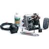
Cylinder Bracket Kit for TR-1 Gold Autopilots
-
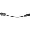
Sonar Ready Adaptor Cables
-
MapSource BlueChart - Italy, Adriatic Sea - Maps
-
Mr F75-D Marine Class-D Digital Selective Calling Technolog
-
000-10620-001 Triton Autopilot Computer - High Current
-
0526004PLB 4" Bronze Deck Plate
-
Series 43 LED Navigation Lights, Ser 43 White LED Nav Light Strbd
-
Vanco Installer Series High Speed - Video / audio / network cable - Male 19 pin HDMI Type A to M 19 pin HDMI Type A
-
Cat6a Ethernet Cable | 1ft | White | Network | 10 Gigabit
-
5 Inch Power Mount Forward Lean Universal Mount with Light Bracket Option PMF-5U-7L (PMF-57-M1 + ADA-R1) wpmf5u7l
-
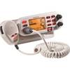
Standard HX370SAS I.S. VHF
-
HDS-5x - Marine Chartplotter - 5" color - 480 x 480