MapSource BlueChart - Jacksonville-Key West - Maps
Model: Brand: Garmin
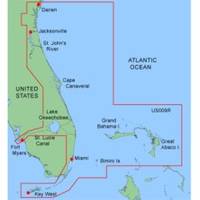
MapSource BlueChart is Garmin's exclusive marine cartography and was developed to provide you with mapping flexibility and options you've never had before. This line of cartography products is designed to provide interactive viewing of detailed nautical chart data, thereby providing navigators with innovative object-oriented cartography. These detailed electronic nautical charts look just like paper charts when displayed on your Garmin chartplotter. Features include shading between depth contours, spot soundings, navaids, port plans, wrecks, obstructions, inter-tidal zones, and more. BlueChart offers much larger coverage areas for half the price. MapSource BlueChart Jacksonville-Key West covers Darien, GA to Key West, FL including the entire St. John's River, the St. Lucie Canal, Lake Okeechobee, with coverage over to Ft. Myers. It also includes detailed coverage of Bimini, the Abacos and Grand Bahama Island, featuring data from explorer charts for the Bahamas. « less
Product Specification
-
General
Product Type: MapsDistribution Media: microSD Memory CardFirst Seen On Google Shopping: January 2006 -
Compatibility Information
Designed For: Garmin eTrex Legend Cx, Vista Cx Garmin GPSMAP 60CSx, 60Cx, 76CSx, 76Cx -
Universal Product Identifiers
Part Numbers: 010-C0344-00, Jacksonville-Key WestGTIN: 00133315570941, 00753759055738
Related Products
-
Kenny Dorham - Show Boat [Audio CD]
-
Seasense 50031802 Lighter/Chart Light Chrome
-
BlueChart g2 Vision - Adriatic Sea, North Coast - Maps
-
1" Seacock Body
-
Marine World Chart of Nicolo de Canerio Januensis [Book]
-
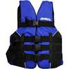
LJ-XXL - Adult Life Vest Size XXL
-
1" IPS Intake Strainer Bronze Made in The USA
-
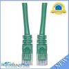
Cat6a Ethernet Cable | 10ft | Green | Network | 10 Gigabit
-
20ft 24AWG CL2 Standard HDMI Cable - White
-
LTD A1530S 15 to 30 Amp 125v/125v Straight Adapter
-
CA50B-9B 50kHz Rbr CTD for 1kW Units
-
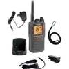
MRHH325VP VHF Two-way radio