MapSource BlueChart - Adriatic Sea, North Coast - Maps
Model: Brand: Garmin
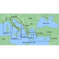
MapSource BlueChart is Garmin's exclusive marine cartography and was developed to provide you with mapping flexibility and options you've never had before. This line of cartography products is designed to provide interactive viewing of detailed nautical chart data, thereby providing navigators with innovative object-oriented cartography. These detailed electronic nautical charts look just like paper charts when displayed on your Garmin chartplotter. Features include shading between depth contours, spot soundings, navaids, port plans, wrecks, obstructions, inter-tidal zones, and more. BlueChart offers much larger coverage areas for half the price. MapSource Adriatic Sea, North Coast provides detailed coverage of Adriatic Sea from Barletta north to Monfalcone, Italy southeast to Dubrovnik, Croatia. It includes detailed coverage of Lago Maggiore, Lago d'Iseo, and Lago d'Garda in Italy. « less
Product Specification
-
General
Product Type: MapsDistribution Media: Garmin Data CardFirst Seen On Google Shopping: January 2006 -
Compatibility Information
Designed For: Garmin GPSMap 172C, 176, 176C, 178C, 178C Sounder, 182, 182C, 188 Sounder, 188C Sounder, 196, 2006, 2006C, 2010, 2010C, 2106C, 2110C, 2206C, 2210C, 232, 238 Sounder, 276C, 292C, 296, 298C, 3006C, 3010c, 3205C, 3206C, 3210C, 376C, 392C, 396C, 492C, 498C -
Universal Product Identifiers
Part Numbers: 010-C0106-00, Adriatic Sea, North Coast
Related Products
-
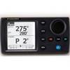
NAVPILOT700OB Autopilot
-
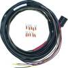
Boat (External) Wiring Harness Johnson/Evinrude OMC Red Plug New 473-9410 Instrument Cable Assembly
-
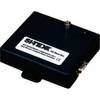
AISBLACKBOX - Assists in Monitoring, Management and Collision P
-
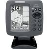
300 Series 161 Combo - Marine Chartplotter - 4" monochrome - 240 x 320
-
11094018 Map, Nova Scotia-st Lawrence River
-
BlueChart g2 Vision - Bretagne - Maps
-
NAVPILOT 711 High-Performance, Universal Autopilot Package
-
49450200Es InHull Transducer
-
30 Amp 50' Cord Set - White - 125V
-
10/3 30 Amp Cable, 250' Spool, Yellow 14179
-
329951-1 UHF Dbl Female Connector
-
22-17 LHR-80 VHforGPS Handheld Marine Radio