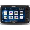
GPSMAP 7215 - Marine Chartplotter - 15" color - 1024 x 768
Model: 7215 Brand: Garmin
Put the power of Garmin's marine navigator right at your fingertips with the GPSMAP 7215. This touch screen chart plotter is the flagship in Garmin's line of full-featured marine products. The GPSMAP 7215 features with video-quality resolution on an impressive 15.5" XGA display. The GPSMAP 7215 also provides total system integration - allowing support for the addition of sonar, radar, weather and more. « less
Product Specification
-
General
Product Type: ChartplotterRecommended Use: MarineCard Reader: SD Memory CardInterface: NMEA 0183, NMEA 2000Functions & Services: Tide TabAntenna: ExternalFeatures: Alarm, XM Satellite Radio support, XM weather supportFirst Seen On Google Shopping: October 2011 -
Display
Type: LCD - color - touch screenDiagonal Size: 15"Resolution: 1024 x 768 -
Navigation
Waypoints: 5000Tracks: 50Tracklog Points: 50000Routes: 100Trip Computer: Sun/moon positions -
Connections
Interfaces: Garmin Marine Network -
Miscellaneous
Protection: WaterproofWaterproof Standard: IPX7Included Accessories: Protective cover, power cable -
Dimensions & Weight
Width: 15.5 inDepth: 5.9 inHeight: 11.9 inWeight: 17.4 lbs -
Universal Product Identifiers
Part Numbers: 010-00748-01, 7215GTIN: 00753759099381
Related Products
-
JMA-3340-6HS Radar 10KW 72 nm, 6 ft Open Array with 27-48 rpm Radar Antenna
-
Mr F75-D Marine Class-D Digital Selective Calling Technolog
-
70M Double Starboard Nav Light
-
DB37 Male / DB37 Male, Serial Cable, 37c, 1:1, 3 ft (UL)
-
250ft 12AWG CL2 Rated 2-Conductor Loud Speaker Cable (for In-Wall Installation)
-
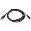
6ft USB A to Mini-B 5pin 28/28AWG Cable
-
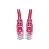
Patch cable - CAT 5e - RJ-45 - M - Unshielded twisted pair (UTP) 100 ft - Red
-
2710 Cover Connector Dual Bus 2702
-
63CM61 Male Plug for 50 AMP/125 Volt
-
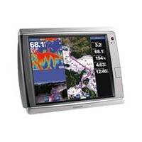
E127 12" Display w/ Sounder and US Coastal Charts
-
5 Inch Power Mount with Light Mount Bracket Option PMF-5F-7L (PMF-57-M1 + ADA-R1) cpmf5f
-
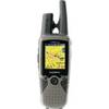
RINO 530HCx - Hiking GPS receiver / two-way radio - Color - 176 x 220