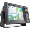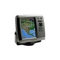
GPSMAP 535s - Marine GPS receiver - 5" color - 640 x 480
Model: 535s Brand: Garmin
This chartplotter provides the brightest, sharpest, most colorful graphics you've ever seen on a 5-inch screen. See clearly as you navigate with the 535's crisp, sunlight-readable VGA display driven by a high-speed processor. This chartplotter offers exceptional detail, fast redraw rates, and the most realistic photo-enhanced cartography ever seen in this class of fixed-mount electronics. The 535 includes U.S. detailed maps of inland lakes. Your basemap can be enhanced with the optional BlueChart g2 Vision card, which provides high-resolution aerial reference photos for help navigating tricky harbors and channels - or locating spots like area marinas, fuel stops or restaurants. The g2 Vision plug-in SD data card card also allows the GPSMAP 535 to graphically depict a true 3D "mariner's eye" topside view or "fish eye" underwater navigation perspective. With fewer buttons to push and fewer operational steps to navigate, the GPSMAP 535's simplified menu format makes it easy for you to see and select the data you want to access on-screen. The 535s comes with powerful dual frequency or dual beam sonar to clearly paint depth contours, fish targets, structure, etc. It's also CANet capable, allowing sounder data to be shared with other plotter displays on your boat. « less
Product Specification
-
General
Product Type: GPS receiverRecommended Use: MarineReceiver: 12 channelCard Reader: SD Memory CardIncluded Software: MapSource BlueChart Inland Lakes: United StatesCompatible Software: BlueChart g2 VisionSBAS: WAASDGPS: DGPS readyAccuracy: Position - 49 ft Velocity - 0.16 ft/sec Position - 10 ft ( with WAAS )Update Rate: 1/secondFeatures: Optional external GPS antenna connectionFirst Seen On Google Shopping: February 2007 -
Display
Type: LCD - colorDiagonal Size: 5"Resolution: 640 x 480Features: Adjustable brightness -
Acquisition Times
Warm: 15 secCold: 45 sec -
Connections
Interfaces: Antenna -
Miscellaneous
Design Features: Rugged caseProtection: WaterproofWaterproof Standard: IPX7Included Accessories: Transom mount transducer, protective cover, mounting bracket -
Dimensions & Weight
Width: 5.9 inDepth: 2.9 inHeight: 6.4 inWeight: 1.8 lbs -
Environmental Parameters
Min Operating Temperature: 5 °FMax Operating Temperature: 131 °F -
Universal Product Identifiers
Part Numbers: 010-00600-00, 535sGTIN: 00753759066147
Related Products
-
Boat (External) Wiring Harness Johnson/Evinrude OMC Black Plug New 473-9430 Instrument Cable Assembly
-
GSC 110 Autopilot Control Head 3.5 Inch Color 40384
-
GTX AIS Class B AIS Transceiver 16 Channel GPS
-
How to read a nautical chart: a complete guide to the symbols, abbreviations, and data displayed on nautical charts [Book]
-
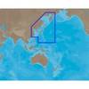
Australia South Platinum Marine Charts on SD Card MSD/61P+
-
Brass Chart Weight Clock & Pen Set
-
AN-M001 SD Card Format East China Sea & Kamchatka
-
Cat6a Ethernet Cable | 5ft | Blue | Network | 10 Gigabit
-
GP1920C-NT VX2 Chartplotter C-Map NT
-
3ft SVGA Super VGA M/M Monitor Cable w/ Ferrites (Gold Plated)
-
1ft 24AWG Cat5e 350MHz UTP Bare Copper Ethernet Network Cable - Black
-
AIS Network Dual Channel Rcvr w/GPS