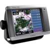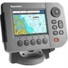
GPSMAP 525 - Marine GPS receiver - 5" color - 640 x 480
Model: 525 Brand: Garmin
This chartplotter provides the brightest, sharpest, most colorful graphics you've ever seen on a 5-inch screen. See clearly as you navigate with the 525's crisp, sunlight-readable VGA display driven by a high-speed processor. This chartplotter offers exceptional detail, fast redraw rates, and the most realistic photo-enhanced cartography ever seen in this class of fixed-mount electronics. The 525's worldwide basemap can be enhanced with the optional BlueChart g2 Vision card, which provides high-resolution aerial reference photos for help navigating tricky harbors and channels - or locating spots like area marinas, fuel stops or restaurants. The g2 Vision plug-in SD data card also allows the GPSMAP 525 to graphically depict a true 3D "mariner's eye" topside view or "fish eye" underwater navigation perspective. With fewer buttons to push and fewer operational steps to navigate, the GPSMAP 525's simplified menu format makes it easy for you to see and select the data you want to access on-screen. « less
Product Specification
-
General
Product Type: GPS receiverRecommended Use: MarineReceiver: 12 channelCard Reader: SD Memory CardInterface: NMEA 0183Included Software: Garmin Worldwide Marine BasemapCompatible Software: BlueChart g2 VisionSBAS: WAASDGPS: DGPS readyAntenna: Built-inAccuracy: Position - 49 ft Velocity - 0.16 ft/sec Position - 10 ft ( with WAAS )Update Rate: 1/secondFeatures: Optional external GPS antenna connectionFirst Seen On Google Shopping: February 2007 -
Display
Type: LCD - colorDiagonal Size: 5"Resolution: 640 x 480Features: Adjustable brightness -
Acquisition Times
Warm: 15 secCold: 45 sec -
Navigation
Waypoints: 1500Tracklog Points: 10000Routes: 20 -
Connections
Interfaces: Antenna -
Miscellaneous
Design Features: Rugged caseProtection: WaterproofWaterproof Standard: IPX7Included Accessories: Protective cover, mounting bracket -
Dimensions & Weight
Width: 5.9 inDepth: 2.9 inHeight: 6.4 inWeight: 1.8 lbs -
Environmental Parameters
Min Operating Temperature: 5 °FMax Operating Temperature: 131 °F -
Universal Product Identifiers
Part Numbers: 010-00597-00, 525GTIN: 00753759066116
Related Products
-
010-N0593-01 - GPSMAP 5208 Noh Chartplotter w/GPS Ant
-
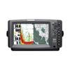
C97 Multifunction 9" Display with Sonar - US Coastal Charts T70021 c44326
-
400540-1 Halogen Chart Light, Large, Brass 20W
-
NA-C304 Furuno FP Format Norfolk Bermuda Jac
-
900 Series 957c Combo - Marine Chartplotter - 8" color - 800 x 480 - widescreen
-
Max AN-M202 W50 Korea Strait, Okinawa Shima-MAX
-
010-C0732-20 Bluechart G2 HXUS031RSouthwest Caribbean microSD
-
32804 4" Tachometer, 6K, Gas Inboard & I/O
-
Marine Products Plug Wire Set 9-28041
-
115V Seawater and Air Distribution Kit for 12,000 BTU Units
-
PiranhaMAX 210 Portable - Fishfinder - portable - included transducer : XNT-9-20-T - single-beam
-
E62184-US - A50 5 Chartplotter, US Maps, Int GPS