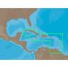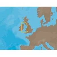
EW-C209 C-Card Format - Irish Sea
Model: EW-C209 Brand: C-Map
Irish Sea: U.K. coverage from Glasgow to Portishead. Ireland coverage from Waterford to Londonderry.
Product Specification
-
Universal Product Identifiers
Part Number: EW-C209C-CARD
Related Products
-
AP5006 Autopilot with AP50, J50, Rudder Feedback RF300, HPU150-12V
-
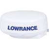
LRA2400 HD Digital 4KW 24 Inch Radar Dome w12109
-
NA-C501 Furuno FP Format Cuba - Trinidad & T
-
3204 Lake Havasu
-
Cat6a Ethernet Cable | 2ft | Orange | Network | 10 Gigabit
-
ZDIGWLEXT USB Self Powered Extension Cable WL400/500
-
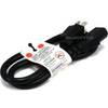
2ft 16AWG Power Cord Cable w/ 3 Conductor PC Power Connector Socket (C13/5-15P) - Black
-
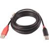
3ft USB 2.0 A Male to A Female Extension 28/24AWG Cable (Gold Plated)
-
Marine Twisted-Pair Y-Adapter Cable - XMD-WHTAIC1F2M
-
30 Amp to 20 Amp, 125 Volt Straight Adapter, Yellow A3020S
-
12.5 Beg Generator
-
lian B3-I2DN I2 System Dish Network All-in-One Package w/Multi-Sa