Canadian Charts 3312 Jervis Inlet and / et Desolation Sound Chart
Model: 3312 Brand:
3312; Canadian charts of the Pacific region Encompasses the Strait of Georgia - Canada Note: Ensure that your charts are kept current to reflect changes to that area
Product Specification
-
Universal Product Identifiers
Part Number: 3312
Related Products
-
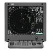
JMA-5332-12 Radar 96 NM with 12' Open Array & 19 Inch LCD Monitor
-
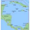
MapSource BlueChart - Southwest Caribbean - Maps
-
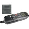
E42001 RAY240 VHF
-
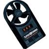
271 Wind Speed INDICATOR, FPM 0 to 8790
-
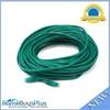
75ft 24AWG Cat5e 350MHz UTP Bare Copper Ethernet Network Cable - Green
-
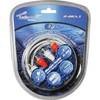
Audiopipe Ip2rca3 2 Ch Marine Oxygen Free RCA Cable 3 ft 2 Channel
-
100ft 24AWG Cat6 500mhz Crossover Ethernet Bare Copper Network Cable - Gray
-
35ft 22AWG 5-rca Component Video/audio Coaxial Cable (RG-59/U) - Black
-
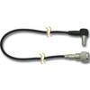
Dgada93m DA93M 3 Adapter Cable with
-
E97 Multifunction Display w/Sonar - US Coastal Charts Map
-
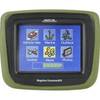
CrossoverGPS 2500T - Marine, hiking, automotive GPS receiver - 3.5" color
-
MDA-1 Metadata Class B AIS Transceiver W Internal GPS