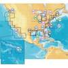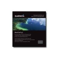
Canada g2 - Maps
Model: Brand: Garmin
See your surroundings more clearly with BlueChart g2 data. With BlueChart g2, you'll get detailed marine cartography that provides convenient viewing of nautical content. BlueChart g2 allows you to see your vessel's precise, on-chart position in relation to navaids, coastal features, anchorages, obstructions, waterways, restricted areas and more. You also will have access to detailed mapping capabilities that include safety shading, fishing charts, smooth data transition between zoom levels, harmonious transition across chart borders, and reduction of chart discontinuities. « less
Product Specification
-
General
Product Type: MapsFirst Seen On Google Shopping: August 2010 -
Universal Product Identifiers
Part Numbers: 010-C1019-20, Canada g2GTIN: 00753759095758
Related Products
-
Training DVD f/Lowrance X47/X47EX/X51/X58DF N2329DVD
-
C97 Multifunction 9" Display with Sonar - European Charts T70023 c44025
-
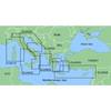
MapSource BlueChart - Ligurian Sea, Corsica and Sardinia - Maps
-
MSD/645P+ Platinum Plus North Carolina on SD/MicroSD
-
75ft 24AWG Cat5e 350MHz UTP Ethernet Bare Copper Network
-
1ft 24AWG Cat5e 350MHz UTP Bare Copper Ethernet Network Cable - Orange
-
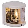
All-Round Navigation Lights, Anchor Light, Series 25, White
-
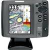
700 Series 787c2i Combo - Marine Chartplotter - 5" color - 640 x 480
-
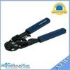
High Quality 8P8C RJ-45 Network Cable Crimper [HT-210C]
-
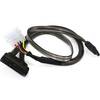
18inch SATA Data and Power Combo Cable - Dark Grey
-
SmartPlug B30ASSY 30 Amp Marine Shore Power Inlet & Connector
-
YQ100PLUS - Adapter Cord Set, 125/250V, Yellow