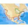
BlueChart g2 Vision - Wrangell to Dixon Entrance - Maps
Model: Brand: Garmin
BlueChart g2 Vision offers the same rich detailed charting of BlueChart g2 to help you get the most out of your unit. In addition, g2 Vision features a growing database of high-resolution satellite imagery, above and below the water 3D perspective, auto guidance technology, aerial photographs for real world reference and coastal roads with points of interest. This product features detailed coverage from Cape Ommaney to Prince Rupert including Prince of Wales Island, Dixon Entrance, Wrangell, AK, Behm Canal, and Observatory Inlet. « less
Product Specification
-
General
Product Type: MapsDistribution Media: SD Memory CardFirst Seen On Google Shopping: May 2007 -
Compatibility Information
Designed For: Garmin GPSMAP 4008, 4012, 420, 4208, 420s, 4212, 430, 430s, 430sx, 430x, 440, 440s, 440sx, 440x, 450, 5008, 5012, 520, 5208, 520s, 5212, 525, 525s, 530, 530s, 535, 535s, 540, 540s, 545, 545s, 550, 550s, 555, 555s -
Universal Product Identifiers
Part Numbers: 010-C0725-00, Wrangell to Dixon EntranceGTIN: 00753759069056
Related Products
-
Commander P2 Mono Display, SSRC1 Rate Gyro Compass & Rotary Feedback 10110031
-
HDS-8 Insight USA Mltfnc 50/200 Fishfinder/Chartplotter 34253
-
Olympic Coast National Marine Sanctuary Habitat Mapping: Survey Report and Classification of Side Scan Sonar Data from Surveys Hmpr-114-2004-02 and Hmpr-116-2005-01 [Book]
-
T70035 C127 Multifunction Display w/Sonar - Row Charts
-
CFFISHW Map, USA Fish N Chip West & Gulf
-
Navigation Light Starboard
-
UM415 Oceanus D Marine Radio (White)
-
3ft 28AWG DisplayPort Cable - White
-
15303 F Type Barrel Connector
-
Marine Products Plug Wire Set 9-28019
-
Inc ETS084230 Computer Hardware
-
PiranhaMAX 215 - Fishfinder - included transducer : XNT-9-20-T - dual-beam