BlueChart g2 Vision - Adriatic Sea, South Coast - Maps
Model: Brand: Garmin
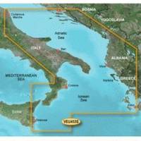
BlueChart g2 Vision offers the same rich detailed charting of BlueChart g2 to help you get the most out of your unit. In addition, g2 Vision features a growing database of high-resolution satellite imagery, above and below the water 3D perspective, auto guidance technology, aerial photographs for real world reference and coastal roads with points of interest. This product features detailed coverage of the Italian coast: from Porto Civitanova to extend south to Siracusa, Sicilia. From Split, Croatia to Killini, Greece « less
Product Specification
-
General
Product Type: MapsDistribution Media: SD Memory CardFirst Seen On Google Shopping: June 2007 -
Compatibility Information
Designed For: Garmin GPSMAP 4008, 4012, 420, 4208, 420s, 4212, 430, 430s, 430sx, 430x, 440, 440s, 440sx, 440x, 450, 5008, 5012, 520, 5208, 520s, 5212, 525, 525s, 530, 530s, 535, 535s, 540, 540s, 545, 545s, 550, 550s, 555, 555s -
Universal Product Identifiers
Part Numbers: 010-C0797-00, Adriatic Sea, South CoastGTIN: 00753759069773
Related Products
-
NAVPILOT 500 Navigational Autopilot with Heading Sensor - No PU
-
Inc. FSDV01 Fish Scout Double Vision w/o Sonar
-
NA-C303 Furuno FP Format Shinnecock Bay Albe
-
AS-M001 C-Card Format Gulf of Thailand - Yellow Sea
-
Fish-N-Map 8263; Map-Lake Shasta
-
The Nautical Chart: A Novel of Adventure [Book]
-
E43032 - VHF, Ray218, w/Hailer, Opt. Remote
-
2" IPS Intake Strainer Bronze Made in The USA
-
150AY Y Adapter, 2-15 20 Amp Straight Blade to 30 Amp Locking
-
PC/NMEA/SeaTalk Interface Box E85001
-
Waterproof VHF DSC w/Hailer White
-
700 Series 785c2 - Marine Chartplotter - 5" color - 480 x 640