Fish-N-Map 8263; Map-Lake Shasta
Model: 8263 Brand:
FISH-N-MAP UNDERWATER TOPOGRAPHY MAPSMade of waterproof, tear resistant plastic. Features include: underwater depth contours, fish locations, latitude and longitude for GPS, multiple freshwater lakes on one map, boat ramps, recreational facilities and much more.
Product Specification
-
Universal Product Identifiers
Part Numbers: 234990, 8263, MSI431890GTIN: 00761428082633
Related Products
-
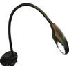
Chart Table Lamp #TM00710
-
NA-C802 Furuno FP Format Gulf of Alaska
-
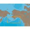
Max IN-M202 W67 Maldives to Gulf of Martaban-MAX
-
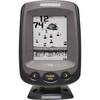
PiranhaMAX 150 - Fishfinder - included transducer : XNT-9-20-T - single-beam
-
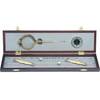
319 Elegant Navigation Set
-
010-C1024-20 Bluechart G2 HXUS401SBermuda Microsd/sd Adaptor
-
240-182 Digital Coaxial/Subwoofer Audio Cable 3 ft. CL2
-
30ft 24AWG Cat6 550mhz UTP Ethernet Bare Copper Network 5017
-
West Marine Electrical Connectors Four Pin
-
127-05 NAC-FRD2FBL Fem. Red to Fem
-
355 2 Conductor Start Interlock Cable
-
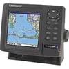
GlobalMap 5200C - Marine GPS receiver - 5" color - 480 x 480