A27 Imray Antigua Marine Nautical Chart
Model: A27 Brand: Weems And Plath
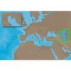
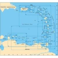
This Imray-Iolaire waterproof chart of Antigua Island includes large scale insets of Nonsuch Bay Mamora Bay Falmouth Bay and English Harbor. The chart is printed in color and uses official surveys and notes based on local knowledge. It is flat with no folds so is suitable for framing. Dimensions: 25 x 35 1/2 (640 x 900 cm). « less
Product Specification
-
Universal Product Identifiers
Part Number: A27
Related Products
-
AP5014 Autopilot with AP50, J50, Rudder Feedback RF300, HLD2000LD (Long Stroke, Dual Drive)
-
010-00705-00 - GHP 10 Autopilot Corepack (Powerboats)
-
T70027 C97 Multifunction Display w/Sonar - US Inland Charts
-
Aa010211 10M Cable for BR24 Radars
-
Ultra Marine Chart Caddy, Teak
-
ME-C005 C-Card Format - Caspian Sea
-
BlueChart g2 Vision - North Maine - Maps
-
E42001 RAY240 VHF
-
PLB-CE3 Ceiling Bracket for 30inch Above TV (To Be Used with PID 2852, 3003, or 3004)
-
RD33 4. 3 in. Color LCD Navigational Data Organizer
-
6/4 50 Amp 250 Volt Cable, 250' Spool, White Super Flex
-
ELB-NM-NF Mini 90 Deg. Male to Female Connector