4119 Channel Isls/Venture - Santa
Model: 4119 Brand: Fish-n-Map
FISH-N-MAP UNDERWATER TOPOGRAPHY MAPSMade of waterproof, tear resistant plastic. Features include: underwater depth contours, fish locations, latitude and longitude for GPS, multiple freshwater lakes on one map, boat ramps, recreational facilities and much more.
Product Specification
-
Universal Product Identifiers
Part Numbers: 4119, 516252GTIN: 00761428041197
Related Products
-
E62192 - A70D 6.4 Combo, Int GPS, w/o Charts
-
LMB-F1 F/ 2KW 4KW Raymarine Garmin Domes
-
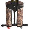
2000007059 Auto/Manual One Size Inflatable Life Vest Jacket
-
POD-3S Electronic Instrument Sail Pod
-
GP230 3 Intrument Uncut (Replaces NP2003)
-
Xblue Switch Computer Hardware
-
10ft 24AWG Cat6 550mhz UTP Ethernet Bare Copper Network Cable - White
-
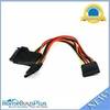
5184 0.2meter 15pin SATA Power Y Cable
-
10ft 28AWG DVI-A to SVGA (HD15) Cable - Black
-
Product FCF0016000GS Air Conditioner 115V FCF16000
-
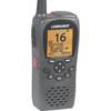
000-0022-17 LHR-80 DSC VHF/GPS Radio
-
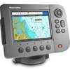
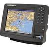
GlobalMap 8300C HD - Marine GPS receiver - 8.4" color - 600 x 800