37637 HotMaps Platinum Multi-Dimensional 3D Lake Maps
Model: 37637 Brand: Navionics
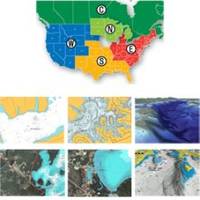
HotMaps Platinum Multi-Dimensional Lake Maps - with 1000 of Navionics exclusive high-definition lake maps to 1' contours featuring 3D bottom view, top-down photo/map overlay and panoramic lake pictures. FREE Fish'N Chip high-definition fishing
Product Specification
-
Universal Product Identifiers
Part Numbers: 11094273, 37637, DEF-257887MSDEA6, HMPT-E6, MSD-HMPT-E6, SD/HMPT-E6GTIN: '82124513594, 00821245135940
Related Products
-
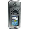
GPSMAP 76Cx - Marine, hiking GPS receiver - 2.6" color - 160 x 240
-
116-07 M68C Deepwater Color S/Map
-
Chartmaster 169CS (u1-Chrt-169i)
-
3G Broadband Radar Kit (000-10418-001)
-
Package(C120W, DSM300G Sounder, 4KW 18 Inch Digital Radome & Radar Cable)
-
Max EN-M604 W34 Russian Lakes-MAX
-
408710-1 958c HD Di Combo
-
Mr F45-D Marine Digital Selective Calling Technology Fixed Mount VHF Radio - White
-
PKG-MR333 - Marine In-Dash Stereo & 6.5" 2-Way Speakers
-
USB 2.0 A Male to Micro-B Male Cable 6 ft.
-
T-H Marine Pp118 Push Plug for 1-1/8 &Amp; 1-1/4
-
DSM30 Digital Network Sounder Module E63074