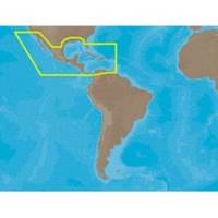
30131 Max - Central America and The Caribbean - C-Card
Model: 30131 Brand: C-Map
Coverage of the Pacific coast starts at Point Conception, CA and runs down to Bahia Cupica, Colombia. Coverage of the United States starts in Cumberland Sound, GA and runs down around Florida and over to Brownsville, TX. Bahamas, Turks and Caicos and all islands of the Caribbean are included. South American coverage includes the northern coasts of Colombia and Venezuela over to Rio Orinoco, including Trinidad and Tobago. Caribbean coverage includes charts from Explorer Chartbooks and Wavey Line Publising. Specifications:Port Plans: YesAerial Photos: Yes3-D View: Yes « less
Product Specification
-
Universal Product Identifiers
Part Numbers: 30131, CMANAM027CCARD, CMANAM027SD, NA-M027, NA-M027-C, NA-M027C-CARDGTIN: 000000165841, 00686074002814
Related Products
-
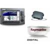
Package(C120W, DSM300G Sounder, 4KW 18 Inch Digital Radome & Radar Cable)
-
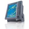
FR8062 12.1 Inch 6KW, 72 nm, 12.1 Color Display Radar 4' Open Array Antenna fr80624
-
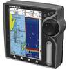
EC5I 5 Inch Color Plotter with Internal GPS
-
Max Mega Wide International cmegai
-
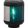
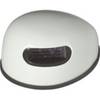
Navigation Light Starboard
-
Innovative Lighting LED Deck Mount Navigation Light - White
-
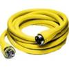
HBL61CM52 - Marine Cord Set, Shore Power, 50ft, 50A
-
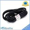
10ft 14AWG Power Cord Cable w/ 3 Conductor PC Power Connector Socket (C13/5-15P) - Black
-
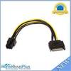
8inch SATA 15pin to 6pin PCI Express Card Power Cable
-
Marine -9-72653 PLUG,DRAIN
-
GlobalMap 7300C HD - Marine GPS receiver - 7" color - 640 x 480
-
386ci GPS Fishfinder 409030-1 c46181