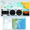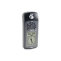
GPS 72 - Marine, hiking GPS receiver - Monochrome - 120 x 160
Model: 120 Brand: Garmin
The GPS 72 is a low-cost solution for land or marine navigation designed to provide precise GPS positioning using correction data obtained from the Wide Area Augmentation System (WAAS). The GPS 72 can provide position accuracy to less than three meters when receiving WAAS corrections. This rugged, waterproof, unsinkable GPS receiver offers a large, 4-level grayscale screen. It's designed as the next generation in basic, entry-level Garmin GPS. « less
Product Specification
-
General
Product Type: GPS receiverRecommended Use: Marine, hikingPreloaded Maps: North America, South AmericaReceiver: 12 channelInterface: Serial, NMEA 0183, RTCM SC-104 DGPSCompatible Software: MapSource Points of InterestGrids: UTM, MGRS, Lat/Lon, UPS, User, Loran TDs, MaidenheadSBAS: WAASDGPS: DGPS readyAntenna: Built-inAccuracy: Position - 49 ft Position - 10 ft - 16 ft ( with DGPS ) Position - 10 ft ( with WAAS ) Velocity - 0.16 ft/secUpdate Rate: 1/secondInternal Memory: 1 MB flashFirst Seen On Google Shopping: October 2003 -
Display
Type: LCD - monochromeResolution: 120 x 160Display Illumination: Yes -
Acquisition Times
Warm: 15 secCold: 45 sec -
Navigation
Waypoints: 500Tracks: 10Routes: 50Waypoints per route: 50Trip Computer: TracBack, average speed, maximum speed, trip timer, sun/moon positions -
Connections
Interfaces: DC power input -
Battery
Type: AA typeRequired Qty: 2Run Time (Up To): 16 hours -
Miscellaneous
Protection: WaterproofWaterproof Standard: IPX7Included Accessories: Wrist strap -
Dimensions & Weight
Width: 2.7 inDepth: 1.2 inHeight: 6.2 inWeight: 7.9 oz -
Environmental Parameters
Min Operating Temperature: 5 °FMax Operating Temperature: 158 °F -
Universal Product Identifiers
Part Numbers: 010-00309-00, 010-00309-01, 010-00309-05, 010-00309-11, 010-00309-15, 72GTIN: 00075375904154, 00753759041540, 00753759041564
Related Products
-
T70045 E97 Multifunction Display w/Sonar - Row Charts
-
HDS 8, 8m, 10, 10m, GPS Chartplotter/Sonar [DVD]
-
CH270BB/324 180 kHz Black Box Searchlight Sonar System. Includes 350mm Travel Hoist and Operates at 24 and 32VDC
-
Radar 4210 Package with GMR24HD 4KW Radome & GSD22 Sounder
-
NA-C402 Furuno FP Format Pensacola Bay Gulf
-
Puerto Bolivar to Rio de Janeiro: NT+ Wide Coverage by C-Map
-
Cal June/Jim-Buoy 101W White Vinyl Buoyant Boat Throw Cushions USCG Approved Type IV-
-
FUGMAR-5 Marine 5 PC Navigation Software
-
30ft 24AWG Cat6 550mhz UTP Ethernet Bare Copper Network Cable - Blue
-
30ft 24AWG Cat6 550mhz UTP Ethernet Bare Copper Network Cable - Green
-
4155 Ferrite cores (1 Pair) for 24AWG HDMI Cable
-
PMF10U7L Forward-Leaning Power Mount