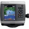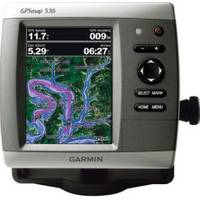
0100077300 Gpsmap536 Plotter
Model: Gpsmap536 Brand: Garmin
Mfr: Garmin - 100077300; These compact GPS/Chartplotters feature an ultra-bright 5" diagonal color display with a high-speed digital design for faster map drawing and panning speeds. Includes a built-in basemap and an easy-to-use interface to help navigate your waters with ease. Accepts BlueChart g2 Vision cards for added features and functionality like high-resolution satellite imagery, 3-D views, and Auto Guidance Technology. 10-32V DC. Other features include AIS support, DSC position display, audible alarms, tide tables, sun & moon informations, NMEA interface, and more. Standard models are GPS/Chartplotters and do not include fishfinding capabilities. Inland Lake maps. 546/546s include the basemap plus U.S. Coastal maps, including Alaska & Hawaii, as well as detailed Bahamas charts. Transducers for S models sold separately. « less
Product Specification
-
Universal Product Identifiers
Part Number: 100077300
Related Products
-
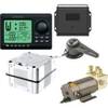
AP2804 Autopilot System AP28,AC42,RC42,RF300,RPU160 32218
-
AP35-19 Autopilot with AP35, J300X, Rudder Feedback RF300, HPU-200 sap3519
-
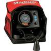
VX-1P 3-Color Sonar Flasher System
-
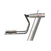
LMB-A2 for SI-TEX Simrad et Al Domes
-
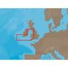
EW-C207 Furuno FP Format - Bristol Channel & Irish Sea
-
Plans - Saltspring Island Chart
-
010-C0763-20 Bluechart G2 HXEU004RIrish Sea Microsd/sd Adaptor
-
1.5ft USB 2.0 A Male to A Female Extension 28/24AWG Cable (Gold Plated)
-
50ft 24AWG Cat6 550mhz UTP Ethernet Bare Copper Network Cable - Purple
-
GPSMAP 421s - Marine Chartplotter - 4" color - 240 x 320
-
EC04110 Blue 16-14 Butt Connector PK10
-
SM-2 Automatic Crew-Overboard Marker Light with Bulkhead Bracket 3940.1