010-C1024-20 Bluechart G2 HXUS401SBermuda Microsd/sd Adaptor
Model: 010-C1024-20 Brand: Garmin
IN STOCK Garmin g2 Data Card HXUS401S Version 2010 v11.5 Provides coverage of Bermuda detailing Saint Georges Island and Harbour, Harrington Sound, Somerset Island, the Great and Little Sounds, Hamilton Island, and Castle Harbour. Garmin BlueChart preprogrammed MicroSD (Micro Secure Digital) data cards feature a compact and small size that makes it easy to pack light and add maps to your compatible Garmin unit when your on the water. Loaded with detail; basic chart navigation, including tides, currents, marine POIs, IALA symbols, perspective chart view and new Fishing Charts and Safety Shading features, invaluable tools for the mariner. Each Garmin BlueChart g2 MicroSD Datacard includes an SD Adapter. (Micro SD Charts work in both SD and MSD devices. The Micro SD chart comes inserted in an SD Adapter. Simply remove the Micro SD chart from the adapter to use in MSD devices.) « less
Product Specification
-
Universal Product Identifiers
Part Numbers: 010-C1024-20, 101-C1024-20, 10807279, 35820, GAR010C102420GTIN: 00753759095550
Related Products
-
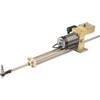
21113360 - HLD-2000 Linear Drive Unit (Long Stroke)
-
Package(C120W, RA1072HD 4KW 72 Inch HD Digital Open Array Radar & 15m Radar Cable)
-
LMB-A3 Self Leveling Radar Mount-LMB-A3
-
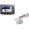
SmartCast RF35 - Fishfinder - portable - included transducer : RF45 - single-beam
-
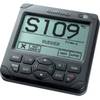
22096267 AP24 Autopilot Display Unit
-
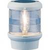
Navigation Light All Round Pedestal Mount, Black Lens
-
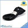
15ft 16AWG Power Cord Cable w/ 3 Conductor PC Power Connector Socket (C13/5-15P) - Black
-
/ Quicksilver 22-861163 Gear Lube Monitor Q-Conn
-
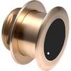
B175-12-M Broadband CHIRP, No CONNECTOR, Depth & Temperature Thru-Hull Tilted
-
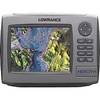
HDS-7m - Marine Chartplotter - 6.4" color - 640 x 480
-
Marine network cable
-
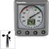
26235 ST60 Plus Wind System with Rotavecta Wind Transducer