010-C1023-20 Bluechart G2 HXEU802XMediterranean Sea & Iberian
Model: 010-C1023-20 Brand: Garmin
NOTE: This preloaded Garmin microSD media is for compatible Garmin units that take microSD memory cards only. This is not for units that require the Garmin proprietary data card. Coverage features the Strait of Gibraltar, the Balearic Islands, the French Riviera, Corsica, Sardinia, Sicily, the Adriatic Sea, the Greek Islands, the Aegean Sea, the Dardanelles and Bosporus Straits, the Sea of Marmara, Cyprus, the Suez Canal, Tripoli and Algiers Harbors, and the Gulfs of Gabes and Tunisia. Also details the Atlantic side of the Iberian Peninsula from the Canary Islands to the Bay of Biscay including the Gulf of Cadiz, the Portugal coast in full, the Gulf of Gascogne, and the Madeira and Azores Islands. « less
Product Specification
-
Universal Product Identifiers
Part Numbers: 010-C1023-20, 10807253, 35817GTIN: 00753759095529
Related Products
-
958c HD Di Down Imaging GPS Fishfinder 408710-1 c46192
-
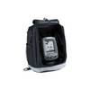
PiranhaMAX 160 - Fishfinder - portable - included transducer : XPT-9-20-T - dual-beam
-
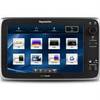
E125 12" Multifunction Display w/ US Coastal Charts
-
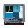
Colormax 15 Color LCD Chartplotter with WAAS GPS
-
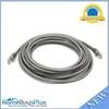
20ft 24AWG Cat6 550mhz UTP Ethernet Bare Copper Network Cable - Gray
-
Power Bright 4 AWG 3 ft Battery Cables
-
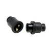
Molded Marine Connector 2 Conducter Seachoice 13801
-
18-8801-1 Premium Marine Spark Plug Wire Leads
-
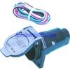
Supply TC44984 Trailer Connector Adapters 7 Pole
-
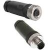
M8A5000-32DN Micro Field-Attachable Connector (Female)
-
Wiring Devices HBL23CM13 CONNECTOR, AC Power, Plug, 20A, 125V
-
5 Inch Power Mount with Light Mount Bracket Option PMF-5F-7L (PMF-57-M1 + ADA-R1) cpmf5f