010-C0759-10 Bluechart G2 HAW451SRed Sea Data Card
Model: 010-C0759-10 Brand: Garmin
HAW451S Covers: Coverage of the Red Sea and Gulf of Aden in their entirety, as well as the Indian Ocean including portions of the coasts of Somalia and Oman. Also includes coverage of the Mediterranean Sea from Beirut, Leb. to Alexandria Egy., including the Suez Canal and Gulf of Aqaba. Included in this overall general coverage are numerous detailed charts covering areas such as Jiddah, Sau., Djibouti, Dji., and Aden, Yem. « less
Product Specification
-
Universal Product Identifiers
Part Numbers: 010-C0759-10, 10804722, 35591GTIN: 00753759091415
Related Products
-
1" Tiller Bracket for Tiller Pilots
-
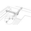
SC111 PowerTower Starboard Mounted Bar for Light, GPS, VHF
-
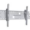
Adjustable Tilting Wall Mount Bracket for LCD LED Plasma (Max 165Lbs, 52~71inch) - Extra Wide - Silver
-
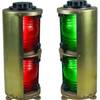
Double Lens, Side Navigation Lights, 120V Volts, 1164 Series, Red
-
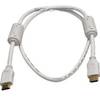
3ft 28AWG High Speed HDMI Cable w/Ferrite cores - White
-
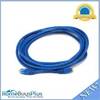
14ft 24AWG Cat5e 350MHz UTP Bare Copper Ethernet Network Cable - Blue
-
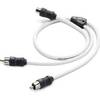
Marine Twisted-Pair Y-Adapter Cable - XMD-WHTAIC1F2M
-
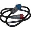
127-05 NAC-FRD2FBL Fem. Red to Fem
-
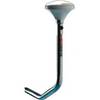
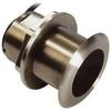
B75-20-M Broadband Chirp 20 Degree Tilt, No CONNECTOR, Depth & Temperature Thru-Hull Tilted
-
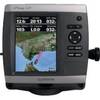
GPSMAP 521s - Marine Chartplotter - 5" color - 234 x 320
-
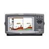
900 Series 931c DF - Fishfinder - included transducer : XHS-9-DB-74-T - dual-beam
-
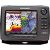
42985 HDS-8 Gen2 Insight USA w/o XD