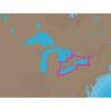
PAPR08; Region 8 Paper Chart Kit
Model: PAPR08 Brand: Maptech
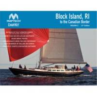
ChartKits are full-color reproductions of U.S. government and private charts spiral bound into popular cruising regions with aerial photos, pre-plotted courses and more. The convenient-sized books are large enough to allow for manual plotting, yet small enough to sit on your nav-station or lap. Waterproof covers are available. « less
Product Specification
-
Universal Product Identifiers
Part Number: PAPR08
Related Products
-
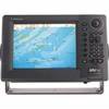
RDP149NT 10.4 Color LCD Waterproof Display C-Map NT
-
Canada g2 - Maps
-
NA-C103 C-Card Format Erie Ontario & Trent Severn
-
Max EN-M018 MW6 European Inland Waters-MAX
-
010-C0747-20 Bluechart G2 HXAF001REastern Africa Microsd/sd ADA
-
4430Mx4-00-000 4430 Inf PFD Sprtmn Chstpk MX4
-
1" IPS Intake Strainer Bronze Made in The USA
-
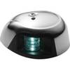
LED Navigation Light Green | Attwood 3530G7
-
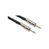
20' 1/4" Phone Male to 1/4" Phone Male Speaker Cable, 14 Awg, with 2 Conductors
-
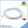
15ft 32AWG Mini DisplayPort | Thunderbolt to VGA Cable - White
-
329957-1 UHF T Connector
-
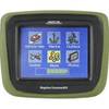
CrossoverGPS 2500T - Marine, hiking, automotive GPS receiver - 3.5" color