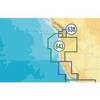
Paper Chart Kit Book REGION03 New York to Nantucket
Model: REGION03 Brand: Maptech
Completely updated. Coastal and offshore coverage. Full-color charts, GPS waypoints, courses and distances, Yeoman points, and color aerial photos. Save hundreds of dollars on charts. 22 X 17, 90 chart pages. Product Overview New features make ChartKits easy to use with your GPS. Most charts include one-minute lat./long. grids to make vessel positioning a breeze, and major navigation aids are identified with named GPS waypoints. GPS Ready New features make ChartKits easy to use with your GPS. Most charts include one-minute lat./long. grids to make vessel positioning a breeze, and major navigation aids are identified with named GPS waypoints. Small and Large Scale Charts ChartKits include small-scale, wide area charts as well as large-scale, detailed charts of harbors and approaches. « less
Product Specification
-
Universal Product Identifiers
Part Number: PAPREGION03
Related Products
-
8M0029350 Wireless Sonar Adapter Vexilar 3 Pin
-
Package(c95 with aus, NZ, S. America, Asia Chart, 4KW 18 Inch Digital Radome & Radar Cable)
-
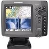
700 Series 798c SI Combo NVB - Fishfinder - included transducer : XNT-9-SI-180-T - dual-beam
-
Fishing Hot Spots E182 Pro Saltwater Chart f/Lowrance
-
MSD/643P+ Platinum Plus Oregon & California - SD/Micro SD
-
50 Amp 25' Cord Set - White - 125/250V
-
3ft Premier Series XLR Male to XLR Female 16AWG Cable (Gold Plated) [Microphone & Interconnect]
-
10ft RG6 (18AWG) 75OHM, Quad Shield, CL2 Coaxial Cable with F Type Connector - Black
-
10gb Fiber Optic Cable, LC/LC, Multi Mode, Duplex - 3 Meter
-
Marine network cable
-
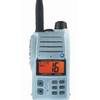
HX500S VHF Radio 5W with Strobe Blk
-
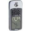
GPS 76 - Marine, hiking GPS receiver - Monochrome - 240 x 180