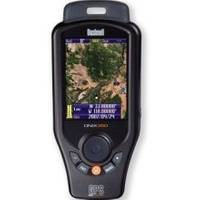
Onix350 HH GPS w/ Georeferenced Satellite Photos
Model: Onix350 Brand: Bushnell
ONIX 350GPS Navigation System - Navigate using an actual satellite photo of your surroundings - layered with all your tools, waypoints and other points of reference. Introducing the world's first handheld GPS to combine navigational aids and satellite photography on a single screen. It's all housed in a rubberized defensive armor built to IPX7 waterproof standards, with a high gain SIRF GPS receiver. In your palm. - Warning: This device is intended as a supplemental navigation aide only. The user assumes all responsibility with the use of this product. - Features:Extra-large 3.5" full color LCD Downloads and displays georeferenced satellite photography Exclusive screen layering Safe - Track battery conservation mode Si - RF Star III 20-channel GPS receiver Digital Compass Embedded 256MB micro SD card Rugged rubber armor Waterproof (IPX7 rated) « less
Product Specification
-
Universal Product Identifiers
Part Number: 363500
Related Products
-
SE-200 BB Sonar w/ 7" Display & Cable No Ducers 41384
-
000-00099-007 - Sst-dfsblk, LSS-1
-
RE-9 Radar engine 4KW 36km 22 in Dome (No Display Included)
-
T70042 E95 Multifunction Display w/European Charts
-
Max AU-M207 W61 Papua New Guinea-MAX
-
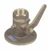
Seacock Body, 3/4 Inch Pipe Size 0805005PLB
-
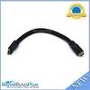
1ft 24AWG CL2 High Speed HDMI Cable w/ Net Jacket - Black
-
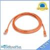
7ft 24AWG Cat5e 350MHz UTP Bare Copper Ethernet Network Cable - Orange
-
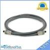
6ft Premium Optical Toslink Cable w/ Metal Fancy Connector
-
100ft Premium Optical Toslink Cable w/ Metal Fancy Connector
-
Wiring Device-Kellems Hbl60cm19 Plug,marine Closure 3d946
-
GPSMAP 4212 Network Bundle Includes GSD22 & Gxm51 p2683