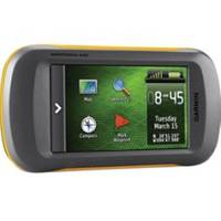
Montana 600 Handheld GPS 41811
Model: 41811 Brand: Garmin
Take it hiking. Take it hunting. Take it on the water. Montana 600 features a bold 4 in. color touchscreen dual orientation display and supports multiple mapping options like Birds - Chart g2 and TOPO U.S. Montana has key features for the outdoors such as a 3-axis tilt-compensated compass and barometric altimeter. Buy the auto mount and a City Navigator NT map and it'll give you spoken turn-by-turn driving directions. It's big. It's versatile. It's tough. It earned the name Montana. Its easy-to-use interface means youll spend more time enjoying the outdoors and less time searching for information. Both durable and waterproof, Montana 600 is built to withstand the elements. Bumps, dust, dirt, humidity and water are no match for this rugged navigator. No matter the setting on the boat, in the RV or on an ATV Montana is right at home. Go Anywhere With an array of compatible mounts, Montana 600 is designed for use on ATV? s, in boats, as a handheld or in your car as a personal navigator. Use the auto mount with City Navigator maps for spoken, turn-by-turn driving directions, or the rugged mount for your motorcycle or ATV. Wherever you think you might take Montana, it has the mapping and mounts to get you there. Go Everywhere Adding more maps is easy with Garmin's wide array of detailed topographic, marine and road maps. With its micro - SD card slot, Montana 600 lets you load TOPO 24K maps and hit the trail, plug in Blue - Montana 600 also supports Birds - Eye Satellite Imagery (subscription required), that lets you download satellite images to your device and integrate them with your maps. In addition, Montana is compatible with Custom Maps , free software that transforms paper and electronic maps into downloadable maps for your device. Share Wirelessly With Montana 600 you can share your waypoints, tracks, routes and geocaches wirelessly with other compatible Garmin GPS users. So now your friends also can enjoy your favorite hike or cache simply press send? to transfer your information to similar units, and let the games begin. Keep Your Fix With its high-sensitivity, WAAS-enabled GPS receiver and Hot - Fix satellite prediction, Montana 600 locates your position quickly and precisely and maintains its GPS location even in heavy cover and deep canyons. Double Your Power Montana 600 features a one-of-a-kind dual battery system. Youll have the option of using the rechargeable lithium-ion pack or traditional AA batteries whichever suits your needs better. Find Fun Montana 600 supports geocaching GPX files for downloading geocaches and details straight to your unit. - Caching.com to start your geocaching adventure. By going paperless, you're not only helping the environment but also improving efficiency. Simply upload the GPX file to your unit and start hunting for caches. Physical & Performance: Unit dimensions, WxHxD: 2.9" x 5.7" x 1.4" (7.48 x 14.42 x 3.64 cm) Display size, Wx - H: 2"W x 3.5"H (5.06 x 8.93 cm); 4" diag (10.2 cm) Display resolution, Wx « less
Product Specification
-
Universal Product Identifiers
Part Number: 41811
Related Products
-
NX45 12.1" Display W/built-in Sounder & GPS Antenna AA010018
-
37593 Escort Sonar Module with Transom Mount, Keypad, Vide
-
CH250BB/150/240 150 kHz Black Box Searchlight Sonar System. Includes 400mm Travel Hoist and Operates at 12VDC
-
SM-24-R Sailboat and Trawler Mast Platform
-
SA-C003 C-Card Format - Rio de Janeiro - Cape Horn
-
Instrument Package - for Harley-Davidson Fairing models 1996-2003 - Blue LED - MCL-3000-OT
-
Smarterchart SC500A 5 Inch Chartplotter with AIS
-
5071 Bi-Color Bow Light-Polished S
-
646 25ft 3.5mm Stereo Plug/Plug M/M Cable - Black
-
Automatic Generator Start 809-0915 (Require Scp System) C16523
-
010-10742-00 Control Area Network (Can) Kit
-
FCF12000 Kit with AC, Seawater & Ducting - 115V FCFK020A