Marine World Chart of Nicolo de Canerio Januensis... [Book]
This is a reproduction of a book published before 1923. This book may have occasional imperfections such as missing or blurred pages, poor pictures, errant marks, etc. that were either part of the original artifact, or were introduced by the scanning process. We believe this work is culturally important, and despite the imperfections, have elected to bring it back into print as part of our continuing commitment to the preservation of printed works worldwide. We appreciate your understanding of the imperfections in the preservation process, and hope you enjoy this valuable book. ++++ The below data was compiled from various identification fields in the bibliographic record of this title. This data is provided as an additional tool in helping to ensure edition identification: ++++ Marine World Chart Of Nicolo De Canerio Januensis; Marine World Chart Of Nicolo De Canerio Januensis; Edward Luther Stevenson Edward Luther Stevenson, American Geographical Society of New York, Hispanic Society of America Hispanic Society of America, 1908 Reference; Atlases; Early maps; Nautical charts; Reference / Atlases; World maps « less
Product Specification
-
Authors: Edward Luther Stevenson, American Geographical Society of New Yor, Hispanic Society of AmericaFormat: paperbackPublication Date: February 22, 2012
-
Universal Product Identifiers
ISBN: 1275700233GTIN: 09781275700239
Related Products
-
AC80S Autopilot Computer 000-10188-001 ac80
-
NSS7 Navigation Pack - NSS7 & 3G Radar c42070
-
FR8062 12.1 Inch 6KW, 72 nm, 12.1 Color Display Radar 6' Open Array Antenna fr80626
-
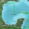
BlueChart g2 Vision - Southern Gulf of Mexico - Maps
-
MOLEX to Dual 4-Pin Floppy Power Adapter Cable - MR1314
-
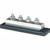
2104 PowerBar 600 Ampere Cable Connector 4 x 3 8 16 Stud ter
-
TNC-Cp/Gs-01 Connector for Rg-58Ua Cable
-
TNC-Cp/Gs-02 Connector for RG-8X Cable tncpgs
-
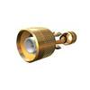
B117-DT-8 600W Thru Hull Transducer Furuno 8-Pin Fuji Connector
-
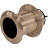
SS264W - 50kHz - 20 Deg - Navico Blue Connector
-
Whisper Whi-500 230V, 3 KW (24Mph Wind) Wind Turbine with Controller
-
D & W 3840RWH 4 Marine Forced Air High Temperature Grille - closable