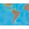
MapSource BlueChart - Southeast Caribbean - Maps
Model: Brand: Garmin
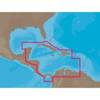
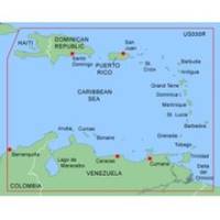
MapSource BlueChart is Garmin's exclusive marine cartography and was developed to provide you with mapping flexibility and options you've never had before. This line of cartography products is designed to provide interactive viewing of detailed nautical chart data, thereby providing navigators with innovative object-oriented cartography. These detailed electronic nautical charts look just like paper charts when displayed on your Garmin chartplotter. Features include shading between depth contours, spot soundings, navaids, port plans, wrecks, obstructions, inter-tidal zones, and more. BlueChart offers much larger coverage areas for half the price. MapSource BlueChart Southeast Caribbean covers the Caribbean from Haiti to Trinidad & Tobago, including Puerto Rico and all of the Lesser Antilles. It also includes the Colombian and Venezuelan coasts from Barranquilla, Colombia to the mouth of the Orinoco River, including Lake Maracaibo and the Gulf of Paria. « less
Product Specification
-
General
Product Type: MapsDistribution Media: microSD Memory CardFirst Seen On Google Shopping: January 2006 -
Compatibility Information
Designed For: Garmin eTrex Legend Cx, Vista Cx Garmin GPSMAP 60CSx, 60Cx, 76CSx, 76Cx -
Universal Product Identifiers
Part Numbers: 010-C0365-00, Southeast CaribbeanGTIN: 00753759055943
Related Products
-
OC15SUK27E Rudder Feed Back Potentiometer Module - Garmin, Fur
-
116-07 M68C Deepwater Color S/Map
-
X126DF Dual Frequency Sonar 117-08
-
Enhanced 4KW Super HD Pedestal 11816816
-
VHF 300i ais, International Garmin 10972206
-
NA-C502 Furuno FP Format Western Caribbean S
-
NA-M027 SD Card Format Central America & Car
-
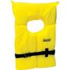
Life Vest Foam Yellow Medium
-
SAS-300 Class B AIS Transceiver w/ 6.5" Tft Disp
-
Bulk cable - CAT 6 - Unshielded twisted pair (UTP) 1000 ft - White
-
SP-80MT Mechanical Dash Drive w/ Built in Feedback
-
24005886 Simnet Connector Protection Plug