MapSource BlueChart - Red Sea - Maps
Model: Brand: Garmin
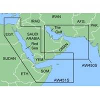
MapSource BlueChart is Garmin's exclusive marine cartography and was developed to provide you with mapping flexibility and options you've never had before. This line of cartography products is designed to provide interactive viewing of detailed nautical chart data, thereby providing navigators with innovative object-oriented cartography. These detailed electronic nautical charts look just like paper charts when displayed on your Garmin chartplotter. Features include shading between depth contours, spot soundings, navaids, port plans, wrecks, obstructions, inter-tidal zones, and more. BlueChart offers much larger coverage areas for half the price. MapSource BlueChart Red Sea covers of the Red Sea and Gulf of Aden in their entirety, as well as the Indian Ocean including portions of the coasts of Somalia and Oman. Also includes coverage of the Mediterranean Sea from Beirut, Leb. to Alexandria Egy., including the Suez Canal and Gulf of Aqaba. Included in this overall general coverage are numerous detailed charts covering areas such as Jiddah, Sau., Djibouti, Dji., and Aden, Yem. « less
Product Specification
-
General
Product Type: MapsDistribution Media: microSD Memory CardFirst Seen On Google Shopping: January 2006 -
Compatibility Information
Designed For: Garmin eTrex Legend Cx, Vista Cx Garmin GPSMAP 60CSx, 60Cx, 76CSx, 76Cx -
Universal Product Identifiers
Part Numbers: 010-C0436-00, Red Sea
Related Products
-
DRS25A NAVNET3D 25KW Gearbox Requires Antenna
-
Elite 5x DSI - Fishfinder - included transducer : Skimmer DSI
-
010-11091-00 Marine Audio/Video Cable, Right Angle
-
Marine Navigation: Celestial and electronic [Book]
-
3" Water Strainer
-
European Style Navigation Lights, Red Side Light, Black Perko
-
USB 2.0 A Male to Micro-B Male Cable 1.5 ft.
-
3ft Toslink to Mini M/M 5.0mm OD Molded Cable 1556
-
Fiber Optic Cable, LC/LC, Multi Mode, Duplex - 15 Meter 4834
-
4-Way Connector for 3/8 Inch Rope Light - Imt-ilmdl-4way
-
Marine Power 441220 Adapter Plate 262 Holley
-
LED Red 11/64" 120VAC