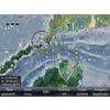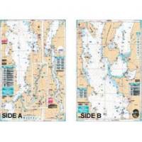
Lake Champlain Fishing South - Waterproof Charts
Designed for recreational boaters, fishermen and divers. Waterproof Charts are beautifully printed on synthetic paper. For use on deck in any weather rain or spray! Accurate, used by Coast Guard and Navy, simple to use with GPS. Foldable and easy to hold and store Waterproof Charts are so tear resistant you can't ruin them. Printed on both sides so they save you money! All Charts are 25"x38" This LARGE PRINT Lake Chart details all of the Major Fishing Areas and pinpoints dozens of specific areas for the major species caught in the area. (Large and Smallmouth Bass, Yellow Perch, Walleye, Muskie, Northern Pike, Salmon & Trout). Many areas have GPS positions. Grass and Marsh areas are also identified. Marinas are listed as well as popular Boat Ramps. From the south, side "A" starts at Whitehall N.Y. and continues north to Burlington Vt. The reverse side continues north from Willsboro Point and Shelburne Bay to Cumberland Head and Savage Island. Information from 3 NOAA Charts; 14782, 14783, 14784. Chart is 25" X 38" and is folded to 7" X 14" « less
Product Specification
-
Universal Product Identifiers
Part Number: 11F
Related Products
-
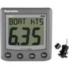
SP-70MT Autopilot for Cable Steer Tilt Type Helms st70mt
-
000-10612-001 Triton Pilot Computer - Low Current
-
010-00484-04 - 6' Open Array for XHD Pedestal
-
000-10041-001 Nautic Insight HD US Coastal East
-
The Nautical Chart - 11 x 17 Movie Poster - Spanish Style A
-
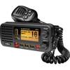
Ite-unnum415bk-ptrind1 Um415Oceanus D Marine Radio
-
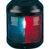
Navigation Light for Bulk Head Mounting , Masthead
-
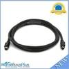
589 6ft S-Video Svideo M/F Extension Cable
-
SBBL Switch Box 2 Ducers1 Unit Blue Connector
-
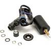
A22009-P ST60 Plus Speed w/Thru Hull Sensor
-
Icom Ic-v8000 Mobile VHF Radio
-
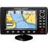
7" GPS Chartplotter W/MAPS