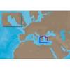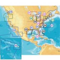
Inc MSD/652P Map, Lake Huron
Model: 652P Brand: Navionics
Navionics 652P+ Lake Huron Platinum+ Multi-Dimensional Charts, with the most advanced technology and best imaging available, provide high-resolution photo/chart overlay, full-view XGA panoramic pictures, improved 3D view, complete geo-referenced coast pilots. Compatibility Guide
Product Specification
-
Universal Product Identifiers
Part Numbers: 11093838, 37651, 652P+, DEF-257881MSD652, MSD-652P-, MSD652P+, SD652PGTIN: '82124565259, 00821245652591
Related Products
-
E12138 SmartPilot X-5 Tiller Grand Prix Corepack - Control H
-
Mini RE-1 Radar engine 2KW 24km 11" 41405
-
EM-C104 C-Card Format Aegean Sea
-
Mark 5x Pro - Fishfinder - included transducer : Skimmer
-
010-C0762-10 Bluechart G2 HEU003RGreat Britain Northeast
-
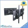
Adjustable Tilting/Swiveling Wall Mount Bracket for LCD LED Plasma (Max 175lbs, 32~60inch) (REV.2.0)
-
Innovative Lighting LED Deck Mount Navigation Light - Stainless Steel
-
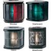
Marine Navigation Lights for Boats to 65'7" Starboard Series
-
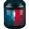
Navigation Light for Bulk Head mounting, Port
-
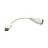
VGA cable Apple mini-DVI - male - 15 pin HD D-Sub (HD-15) - female
-
Cat6a Ethernet Cable | 15ft | Black | Network | 10 Gigabit
-
3ft 24AWG Cat5e 350MHz UTP Ethernet Bare Copper Network 133