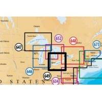
Inc MSD/649P Map, Lake Erie & Saint Clair
Model: 649P Brand: Navionics
Navionics 649P+ Lake Ontario Platinum+ Multi-Dimensional Charts, with the most advanced technology and best imaging available, provide high-resolution photo/chart overlay, full-view XGA panoramic pictures, improved 3D view, complete geo-referenced coast pilots. Compatibility Guide
Product Specification
-
Universal Product Identifiers
Part Numbers: 11093846, 37652, 649P+, DEF-257881MSD649, MSD-649P-, MSD649P+, SD649P, SD/649P+GTIN: '82124564959, 00821245649591
Related Products
-
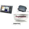
Package(C90W, DSM300G Sounder, 4KW 24 Inch Digital Radome & Radar Cable)
-
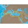
EM-M112 C-Card Format Aegean Sea
-
PFD 33 Gram Manual Inflatable Chest Pak in Navy Size: Small / Medium
-
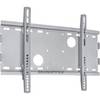
Low Profile Wall Mount Bracket for LCD LED Plasma (Max 165Lbs, 23~37inch) - Silver
-
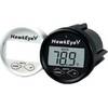
D10DX06T D10DX.06T Depth Sounder
-
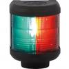
Navigation Light Bi Color
-
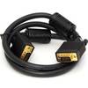
3ft SVGA Super VGA M/M Monitor Cable w/ Ferrites (Gold Plated)
-
9 Pin/ 6pin Bilingual FireWire 800 - FireWire 400 Cable, 15ft, Clear
-
010-11324-00 - Gra 10 Rudder Angle Adpt
-
Cat6a Ethernet Cable | 1ft | Blue | Network | 10 Gigabit
-
500 Series 535 Portable - Fishfinder - portable - included transducer - single-beam
-
2829 SR203 VHF GMDSS Survival Radio